
Cairo
Featured
0
Location
City / Location
Cairo
State or Province
Al Qahirah
Country
Egypt
Population
9908788
Do you have a question or just want to share information with other users regarding this location? Visit this area's Users Group.
For places to visit in this area, check out the following categories:
+ Map this area using Google
+ Geolocate = Towns currently around me
+ Submit a new local listing
+ To report an update to this Listing, please click on the "Send Inquiry" button above.
| RADIUS SEARCH: | MI. | KM. | |
|---|---|---|---|
| ✔ | What's Nearby | 45 | 72 |
| ✔ | Places to Eat / Drink | 45 | 72 |
| + Wineries, Breweries, Pubs | 45 | 72 | |
| ✔ | Places to Stay | 45 | 72 |
| + Campgrounds & RV Parks | 45 | 72 | |
| ✔ | Outdoors | 45 | 72 |
| + Parks, Trails, Beaches | 45 | 72 | |
| ✔ | Golf | 45 | 72 |
| ✔ | Entertainment | 45 | 72 |
| ✔ | Museums & Galleries | 45 | 72 |
| ✔ | Religious Sites | 45 | 72 |
| ✔ | Health | 60 | 96 |
| ✔ | Getting Around | 60 | 96 |
| ✔ | Airports | 60 | 96 |
| ✔ | Cities, Towns, Villages | 60 | 96 |
+ Map this area using Google
+ Geolocate = Towns currently around me
+ Submit a new local listing
+ To report an update to this Listing, please click on the "Send Inquiry" button above.
Cairo (القاهرة) is the capital of Egypt and the largest city in the Arab world. Its metropolitan area, with a population of over 20 million, is the largest in Africa, the Arab world, and the Middle East, and the 6th-largest in the world.
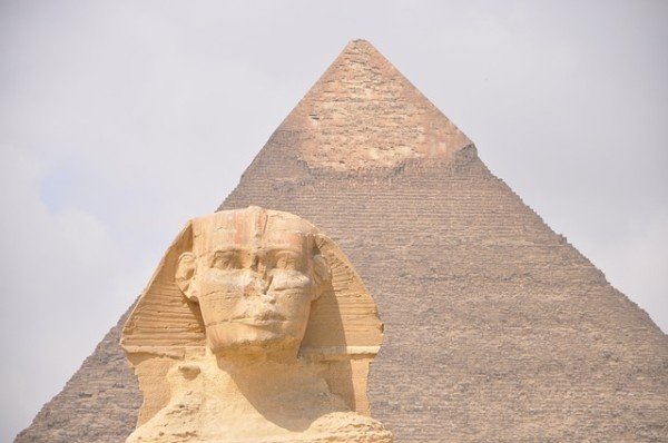
Cairo is associated with ancient Egypt, as the famous Giza pyramid complex and the ancient city of Memphis are located in its geographical area.
Located near the Nile Delta, Cairo was founded in 969 AD by the Fatimid dynasty, but the land composing the present-day city was the site of ancient national capitals whose remnants remain visible in parts of Old Cairo.
With a population of over 9 million spread over 3,085 square kilometers (1,191 sq mi), Cairo is by far the largest city in Egypt. An additional 9.5 million inhabitants live in close proximity to the city.
GEOGRAPHY
Cairo is located in northern Egypt, known as Lower Egypt, 165 kilometres (100 mi) south of the Mediterranean Sea and 120 kilometres (75 mi) west of the Gulf of Suez and Suez Canal. The city lies along the Nile River, immediately south of the point where the river leaves its desert-bound valley and branches into the low-lying Nile Delta region.
Although the Cairo metropolis extends away from the Nile in all directions, the city of Cairo resides only on the east bank of the river and two islands within it on a total area of 453 square kilometres (175 sq mi).
CLIMATE
In Cairo, and along the Nile River Valley, the climate is a hot desert climate. Wind storms can be frequent, bringing Saharan dust into the city, from March to May and the air often becomes uncomfortably dry.
High temperatures in winter range from 14 to 22 °C (57 to 72 °F), while night-time lows drop to below 11 °C (52 °F), often to 5 °C (41 °F). In summer, the highs rarely surpass 40 °C (104 °F), and lows drop to about 20 °C (68 °F).
Rainfall is sparse and only happens in the colder months, but sudden showers can cause severe flooding. The summer months have high humidity due to its coastal location.
NEW ADMINISTRATIVE CAPITAL
In March 2015, plans were announced for a yet-unnamed planned city to be built east of Cairo, in an undeveloped area of the Cairo Governorate, which would serve as the administrative and financial capital of Egypt.
CITYSCAPE
Tahrir Square was founded during the mid 19th century with the establishment of modern downtown Cairo. It was first named Ismailia Square, after the 19th-century ruler Khedive Ismail, who commissioned the new downtown district's 'Paris on the Nile' design. After the Egyptian Revolution of 1919 the square became widely known as Tahrir (Liberation) Square, though it was not officially renamed as such until after the 1952 Revolution which eliminated the monarchy.
The Museum of Egyptian Antiquities, known commonly as the Egyptian Museum, is home to the most extensive collection of ancient Egyptian antiquities in the world. It has 136,000 items on display, with many more hundreds of thousands in its basement storerooms. Among its most famous collections on display are the finds from the tomb of Tutankhamun.
Much of the collection of the Museum of Egyptian Antiquities, including the Tutankhamun collection, are slated to be moved to the new Grand Egyptian Museum, under construction in Giza and due to open by the end of 2020.
The Cairo Tower is a free-standing tower with a revolving restaurant at the top. It provides a bird's eye view of Cairo to the restaurant patrons. It stands in the Zamalek district on Gezira Island in the Nile River, in the city centre. At 187 metres (614 feet), it is 44 metres (144 feet) higher than the Great Pyramid of Giza, which stands some 15 kilometres (9 miles) to the southwest.
OLD CAIRO
This area of Cairo is so-named as it contains the remains of the ancient Roman fortress of Babylon and also overlaps the original site of Fustat, the first Arab settlement in Egypt (7th century AD) and the predecessor of later Cairo.
The area includes the Coptic Cairo, which holds a high concentration of old Christian churches such as the Hanging Church, the Greek Orthodox Church of St. George, and other Christian or Coptic buildings, most of which are located over the site of the ancient Roman fortress.
It is also the location of the Coptic Museum, which showcases the history of Coptic art from Greco-Roman to Islamic times, and of the Ben Ezra Synagogue, the oldest and best-known synagogue in Cairo, where the important collection of Geniza documents were discovered in the 19th century.
To the north of this Coptic enclave is the Amr ibn al-'As Mosque, the first mosque in Egypt and the most important religious centre of what was formerly Fustat, founded in 642 AD right after the Arab conquest but rebuilt many times since.
The areas around the old walled city and around the Citadel are characterized by hundreds of mosques, tombs, madrasas, mansions, caravanserais, and fortifications dating from the Islamic era and are often referred to as "Islamic Cairo", especially in English travel literature.
It is also the location of several important religious shrines such as the al-Hussein Mosque, the Mausoleum of Imam al-Shafi'i, the Tomb of Sayyida Ruqayya, the Mosque of Sayyida Nafisa, and others.
The Mosque of Ibn Tulun is the oldest mosque that still retains its original form and is a rare example of Abbasid architecture from the classical period of Islamic civilization. It was built in 876–879 AD in a style inspired by the Abbasid capital of Samarra in Iraq. It is one of the largest mosques in Cairo and is often cited as one of the most beautiful.
Another Abbasid construction, the Nilometer on Rhoda Island, is the oldest original structure in Cairo, built in 862 AD. It was designed to measure the level of the Nile, which was important for agricultural and administrative purposes.
One of the most important and lasting institutions founded in the Fatimid period was the Mosque of al-Azhar, founded in 970 AD, which competes with the Qarawiyyin in Fes for the title of oldest university in the world. Today, al-Azhar University is the foremost Center of Islamic learning in the world and one of Egypt's largest universities with campuses across the country.
Other extant monuments from the Fatimid era include the large Mosque of al-Hakim, the Aqmar Mosque, Juyushi Mosque, Lulua Mosque, and the Mosque of Al-Salih Tala'i.
The most prominent architectural heritage of medieval Cairo, however, dates from the Mamluk period, from 1250 to 1517 AD. The Mamluk sultans and elites commonly built religious or funerary complexes whose functions could include a mosque, madrasa, khanqah (for Sufis), a sabil (water dispensary), and a mausoleum for themselves and their families.
Among the best-known examples of Mamluk monuments in Cairo are the huge Mosque-Madrasa of Sultan Hasan, the Mosque of Amir al-Maridani, the Mosque of Sultan al-Mu'ayyad (whose twin minarets were built above the gate of Bab Zuwayla), the Sultan Al-Ghuri complex, the funerary complex of Sultan Qaytbay in the Northern Cemetery, and the trio of monuments in the Bayn al-Qasrayn area comprising the complex of Sultan al-Mansur Qalawun, the Madrasa of al-Nasir Muhammad, and the Madrasa of Sultan Barquq.
The Mamluks, and the later Ottomans, also built wikalas or caravanserais to house merchants and goods due to the important role of trade and commerce in Cairo's economy. The most famous example still intact today is the Wikala al-Ghuri, which nowadays also hosts regular performances by the Al-Tannoura Egyptian Heritage Dance Troupe. The famous Khan al-Khalili is a commercial hub which also integrated caravanserais (also known as khans).
The Citadel is a fortified enclosure begun by Salah al-Din in 1176 AD on an outcrop of the Muqattam Hills as part of a large defensive system to protect both Cairo to the north and Fustat to the southwest. It was the centre of Egyptian government and residence of its rulers until 1874. It is still occupied by the military today, but is now open as a tourist attraction comprising, notably, the National Military Museum, the 14th century Mosque of al-Nasir Muhammad, and the 19th century Mosque of Muhammad Ali which commands a dominant position on Cairo's skyline.
Khan el-Khalili is an ancient bazaar, or marketplace adjacent to the Al-Hussein Mosque. It dates back to 1385, when Amir Jarkas el-Khalili built a large caravanserai, or khan. (A caravanserai is a hotel for traders, and usually the focal point for any surrounding area.)
This original carvanserai building was demolished by Sultan al-Ghuri, who rebuilt it as a new commercial complex in the early 16th century, forming the basis for the network of souqs existing today. Many medieval elements remain today, including the ornate Mamluk-style gateways. Today, the Khan el-Khalili is a major tourist attraction and popular stop for tour groups.
TRANSPORTATION
Cairo has an extensive road network, rail system, subway system and maritime services. Road transport is facilitated by personal vehicles, taxi cabs, privately owned public buses and Cairo microbuses. Cairo, specifically Ramses Square, is the centre of almost the entire Egyptian transportation network.
ROADS & HIGHWAYS
An extensive road network connects Cairo with other Egyptian cities and villages. There is a new Ring Road that surrounds the outskirts of the city, with exits that reach outer Cairo districts. There are flyovers and bridges, such as the Sixth of October bridge that, when the traffic is not heavy, allow fast means of transportation from one side of the city to the other.
Cairo traffic is known to be overwhelming and overcrowded. Traffic moves at a relatively fluid pace. Drivers tend to be aggressive, but are more courteous at junctions, taking turns going, with police aiding in traffic control of some congested areas.
RAILWAYS
The Cairo Metro is one of the only two metro systems in Africa (the other being in Algiers, Algeria), and ranks amongst the fifteen busiest in the world, with over 1 billion annual passenger rides.
The subway system, officially called "Metro (مترو)", is a fast and efficient way of getting around Cairo. Metro network covers Helwan and other suburbs. It can get very crowded during rush hour. Two train cars (the fourth and fifth ones) are reserved for women only, although women may ride in any car they want.
Map
User reviews
There are no user reviews for this listing.
Already have an account? Log in now or Create an account
{{#ratings}}
{{title}}
{{#ownerCreatedBlock}}
{{/ownerCreatedBlock}}
{{#category}}
{{#editor}}
{{/editor}}
{{#user}}
{{/user}}
{{/ratings}}
-
{{#owner}}
-
{{#url}}
{{#avatarSrc}}
{{name}} {{/url}} {{^url}} {{#avatar}} {{& avatar}} {{/avatar}} {{name}} {{/url}} - {{/owner}} {{#created}}
- {{created}} {{/created}}
Category: {{category.title}}
{{/category}}
{{#fields}}
{{#showLabel}}
{{/fields}}
{{label}}:
{{/showLabel}}
{{& text}}