
Surprising fact: this protected area spans over 36,000 hectares and contains a gorge system that runs 19 km, with roughly 10 km open for visitors — a scale that changes how you plan your visit.
You’ll find semi-virgin beech forests, limestone canyons, and caves that host rare orchids and big mammals. The setting is raw beauty and offers a true nature escape in the region.
This friendly guide gives you a quick roadmap so you can spend your limited time well. Expect clear notes on hikes, lakes, caves, and the historic rail line, plus smart tips on access and seasons.
Who it suits: casual walkers, eager nature lovers, and anyone ready for quieter moments at dawn or dusk. Practical facts like 100+ km of routes and the 1,447 m peak help you plan your trip with confidence.
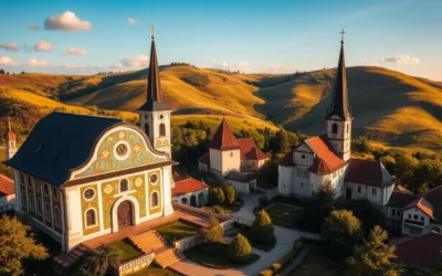
Why You’ll Love Semenic – Cheile Carașului: Untamed beauty, ancient forests, and wild gorges
Step into a landscape where sheer limestone walls and age-old beech groves set the tone for every trail. You’ll feel the wild heart of the area right away: deep gorges, mossy shade, and quiet river bends invite slow, focused exploration.

Signature highlights at a glance
The Cheile Carașului gorge stretches about 19 km, with roughly 10 km open to visitors and drops over 200 m in places. Ancient beech trees—some more than 350 years old—form one of Europe’s largest semi-virgin stands. Spring brings more than 30 orchid species, helped by mild, Mediterranean-influenced summers.
Quick facts: altitude, climate, and wildlife you might spot
Piatra Goznei tops out at 1,447 m, and trails total over 100 km. Average temps range 4–6°C by altitude; summers hit 20–25°C while winter days sit near -5 to 0°C. Keep an eye for deer and fox, and understand that brown bear, wolf, and lynx are possible sightings—respectful distance keeps both you and the wildlife safe.
Epic hiking and nature walks: 100+ km of hiking trails through beech forests and ridge views
Stretch your legs on more than 100 km of marked routes that thread beech forests, ridges, and river valleys. The network around Semenic, Anina, and the gorge area offers mostly easy-to-moderate options. You’ll find family-friendly loops and longer ridge walks in one place.
Trails here have generally gentle altitude differences, so casual hikers can enjoy long views without steep climbs. Official route notes exist, though some are in Romanian only. Cell signal can be patchy, so rely on an offline map and a paper backup.

Top easy-to-moderate routes near Semenic, Anina, and the gorge
- Short forest loops for families—flat, shaded, and 1–3 hours.
- Ridge viewpoints—moderate effort, great sunrise and ridge light.
- Valley tracks along the river—gentle grades and stream crossings.
What to pack and trail safety
Bring sturdy footwear, layered clothing, rain protection, and compact camera gear. Download an offline map and carry a paper copy. Markings are present but can fade; plan your time on the track with buffers for photos and breaks.
| Need | Why it matters | Quick tip |
|---|---|---|
| Sturdy footwear | Grip on wet rocks and roots | Trail shoes with ankle support |
| Offline map + paper | Spotty cell and faded blazes | Download before you go; mark route on paper |
| Sealed snacks | Keeps wildlife safe and distant | Use scent-proof containers and pack out trash |
| Light tripod & lens | Better ridge and forest photos | Choose lightweight kit for comfort |
Cheile Carașului (Caras Gorges): Romania’s wild corridor of limestone, river bends, and views
Walk the gorge slowly and you’ll find sudden openings where sheer walls and river bends steal the scene. The cheile carasului national stretches 19 km in total, but you should focus your visit on the roughly 10 km that are visitable. Here the cliffs drop over 200 m in places and a winding river carves narrow, dramatic frames.
Best viewpoints and visitable sections
- Concentrate on the accessible corridor where most striking river bends and cliff angles cluster.
- Allow extra time—short distances can take longer because footing near the water is often wet and rocky.
- Look for cave mouths at the cliff bases; many are for viewing only unless you join a guided speleo trip.
Photography tips: golden light, composition, and reflections
Aim for morning or late afternoon—golden light warms limestone textures and gives calm river reflections that suit a wide-angle camera. Compose wide shots that show scale: vertical walls against the ribbon of water. Take tighter frames that highlight rock patterns, moss, and natural “windows.”
Bring waterproof boots, trekking poles, a compact tripod, and a microfiber cloth to wipe spray from your lens. Give yourself time to linger at key bends; the distance looks short on a map, but careful pacing reveals the gorge’s true beauty.

Caves and speleology: from Comarnic to Liliecilor—step into Romania’s underground
Step into the cool dark of the karst beneath the ridges and you’ll meet an entirely different world. Start with visitor-friendly caves such as Peștera Comarnic and Peștera Văleaga. They show stalactites and roomy chambers without technical sections.

Other accessible sites include Azuga, Țolosu, Peștera Liliecilor, and De Sub Cetate. If you want more challenge, join a qualified speleo guide for deeper passages. The Banat area has a pit-cave that drops 236 m—this is strictly technical.
Going deeper safely
- Carry a paper map for approach paths and follow the guide underground.
- Wear helmets, reliable headlamps, gloves, and grippy footwear.
- Expect cooler, damp air and move slower—time passes differently below ground.
- Respect sensitive species like bats: avoid bright lights and loud noise near roosts.
| Item | Why | Tip |
|---|---|---|
| Extra batteries | Light failure is risky | Pack spares in a drybag |
| Small group | Less impact, easier comms | Limit party size |
| Local permission | Some areas close seasonally | Check access rules first |
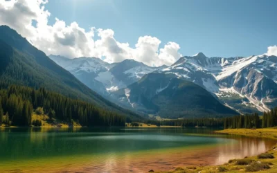
Lakes, rails, and adrenaline: Văliug, Trei Ape, and the Oravița-Anina historic line
Head for the lakes and the old rail line when you want a mix of chill time and scenic motion. Văliug and Trei Ape sit on the park’s edge and are perfect for a relaxed day by the water.
Rent a boat or a pedal boat, swim when the weather allows, and sunbathe between hikes. Văliug’s pontoon comes alive on weekends with music and crowds; weekdays are quieter for reading and long views.
 of the Semenic-Cheile Carasului National Park in Romania. The foreground features the still, reflective waters of the three interconnected lakes, surrounded by lush, verdant vegetation. The middle ground depicts rugged, rolling hills and rocky outcroppings, while the background is dominated by a range of majestic, snow-capped mountains under a bright, clear sky. Warm, diffused sunlight bathes the scene, creating a peaceful, idyllic atmosphere. The image captures the natural beauty and tranquility of this remarkable natural wonder.")
Ride the “Semmering of Banat” for a different pace. The Oravița–Anina line covers about 40 km in nearly three hours (roughly 17 km/h), winding through tunnels, bridges, and forest slopes.
- Expect historic carriages and, on lucky days, a vintage steam engine that make the trip memorable.
- Use a car for flexible lake hopping and rail access; some roads narrow and get muddy after rain.
- Plan your distance and transfers—train schedules are limited and the pace is intentionally unhurried.
Carry cash for rentals and snacks, pack a light windbreaker for cool breezes, and arrive early if you prefer to avoid heavy tourist crowds.
Winter wonderland and two-wheel thrills: skiing, Nordic tracks, enduro, and downhill
When snow falls, this upland turns into a calm playground for skiers and riders alike. You’ll find quieter slopes and classic Nordic tracks that suit low-crowd winter days near Semenic.
Where to ski and what to expect:
Typical winter daytime temps run about -5 to 0°C, so dress in moisture-wicking base layers, an insulated mid-layer, and a windproof shell. Nordic routes cross meadows and forest lanes for steady, scenic glides.

Enduro and downhill basics
When snow melts, you’ll switch to enduro or downhill riding. Trails range from flowy singletrack to technical lines. Check recent trail reports before you go; conditions change fast after rain.
- Bring protective gear: helmet, gloves, pads, and basic tools/spares.
- Use road access carefully—some approaches are narrow or rutted and need higher clearance after storms.
- Plan your day around daylight windows and pack hot tea and snacks for quick energy.
| Activity | Typical conditions | Quick tip |
|---|---|---|
| Skiing | Quiet local slopes, groomed and tracked | Start early for best light and firm snow |
| Nordic track | Open meadows and forest lanes | Wax for cold temps; glide socks matter |
| Downhill/Enduro | Dry to loose soil when thawed | Ride with a partner; carry spares |
Consider hiring a local guide for snow safety or to unlock lesser-known bike lines when the season turns. Respect mixed-use routes, yield politely, and you’ll get a peaceful, rewarding day of activities inside the park.
Semenic-Cheile Carasului National Park, Romania: Best Things to Do – Top Picks
Choose your season and the area rearranges itself around your plans. Spring bursts with 30+ orchid species and bright greens. Summer focuses on lake fun at Văliug and Trei Ape. Autumn riffs on golden beech leaves. Winter brings quiet trails, skiing, and snowshoe days.
Nearby must-sees
Add easy side visits that complement hiking and caving. See Peștera Comarnic and Peștera Popovat for formations. Walk the headwaters at Izvoarele Carașului and the rugged Cheile Gârliștei for dramatic gorges and river views.

Getting there and getting around
Driving is the most flexible option; follow DJ582 from Caransebeș toward Semenic. Public buses work but expect 2–3 hour transfers. From Timișoara Airport it’s roughly a two-hour car drive.
For short windows or complex routes, hire a local guide. A guide helps on tricky trails, in caves, and with wildlife notes. Carry cash for small vendors and agree fares in advance for taxis (roughly 200–300 RON from nearby areas).
Weather, timing, and packing
Check the weather before you go—storms move fast in summer and daylight is short in winter. Download an offline map and keep a paper copy. Pack a waterproof shell, insulating layers, good shoes, and a compact camera for changing light and altitude shifts.
| Aspect | Why it matters | Quick tip |
|---|---|---|
| Roads | Some are narrow and muddy | Use a car with clearance when possible |
| Guide | Improves safety and local insight | Hire for caves or remote trails |
| Map | Cell signal is patchy | Download offline and carry paper |
Conclusion
Finish strong. Choose a final day that ties a sunrise forest walk, a midday cave visit, and a golden-hour gorge stop into one tidy loop. This small plan shows the full range of the national park without rushing.
Make your hikes count: pick routes that match your time and season. Bring layers, offline maps, and a local guide when you want deeper insight or added safety.
The place blends 100+ km of trails, ancient beech woods, dramatic limestone gorges, lakes, and a storied rail line. That mix of scale and detail is the real beauty—and it’s what keeps the heart of the park surprising all year.
Leave no trace, keep curiosity handy, and you’ll carry the park’s quiet rewards home with you.
The above is subject to change.
Check back often to TRAVEL.COM for the latest travel tips and deals.


0 Comments