
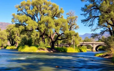
Few visitors realize that the South Yuba River’s crystal-clear waters flow through one of the most significant gold rush regions in California, where over 3 million ounces of gold were extracted during the 19th century. Today, this hidden gem in the Sierra Foothills offers visitors a perfect blend of natural beauty, history, and outdoor adventure just a short drive from Sacramento.
Getting There & Planning Your Journey
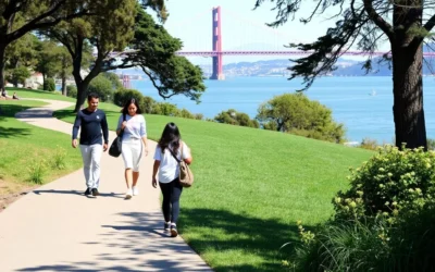
South Yuba River State Park is nestled in the Sierra Nevada foothills of Northern California, approximately 113 km (70 miles) northeast of Sacramento. The park stretches along 32 km (20 miles) of the South Yuba River, with multiple access points and recreational areas.
The closest major airports to the park are:
- Sacramento International Airport – 113 km (70 miles)
- Reno-Tahoe International Airport – 129 km (80 miles)
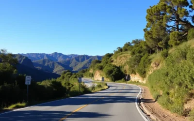
From Sacramento, take Interstate 80 east toward Reno, then Highway 49 north to reach the park’s main access points. The most popular entry points include Bridgeport, Highway 49 Crossing, and Purdon Crossing. Each offers different amenities and access to various sections of the river.
Best Time to Visit & Weather Tips

The South Yuba River experiences distinct seasonal changes that significantly impact your visit. Understanding these patterns will help you plan the perfect trip.
Recommended Seasons
Spring (April-June)
Spring offers moderate temperatures ranging from 18-26°C (65-80°F) with spectacular wildflower displays along the Buttermilk Bend Trail. The river flows vigorously from snowmelt, creating dramatic waterfalls. While some swimming holes may be too cold and swift for swimming in early spring, late spring offers perfect hiking conditions.
Fall (September-October)
Fall brings pleasant temperatures of 21-29°C (70-85°F) and fewer crowds. The river water is warmer from summer heat, making swimming more enjoyable. Fall colors add beauty to the landscape, and hiking conditions are ideal with cooler temperatures and stable weather patterns.
Seasons to Avoid
Summer Peak (July-August)
While summer offers ideal swimming conditions with temperatures often reaching 32-38°C (90-100°F), it brings extremely crowded conditions. Parking lots typically fill by 10:30 AM on weekends, and the most popular swimming holes can become overcrowded. If visiting in summer, arrive very early or on weekdays.
Winter (November-March)
Winter brings temperatures of 7-15°C (45-60°F) with frequent rain and occasional snow at higher elevations. Many trails become muddy, and the river can be dangerously high and swift after storms. However, winter offers solitude and beautiful misty views for photographers willing to brave the elements.
Getting Around Locally
A personal vehicle is essential for exploring South Yuba River State Park, as public transportation options are extremely limited in this rural area. The park stretches along multiple access points, with considerable distances between them.
Cell service is virtually non-existent within the river canyon. Download offline maps before your visit and plan your route in advance. GPS may be unreliable in some areas of the park.
The main access points are connected by winding mountain roads that require careful driving. During peak summer weekends, parking can be extremely challenging. If lots are full, rangers may restrict access, so having alternative locations in mind is advisable.
For those without a vehicle, limited shuttle services occasionally operate from Nevada City during peak summer weekends, but these are not reliable for planning purposes.
Where to Stay

While there are no accommodations within South Yuba River State Park itself, the surrounding area offers a variety of lodging options to suit different preferences and budgets.
Nearby Towns
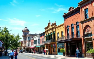
Nevada City (20 km/12 miles)
This charming Gold Rush-era town offers Victorian bed and breakfasts, boutique hotels, and vacation rentals. Its historic downtown features excellent dining options and a vibrant arts scene, making it an ideal base for exploring the river.
Grass Valley (24 km/15 miles)
Slightly larger than Nevada City, Grass Valley provides more conventional hotel options, including national chains and budget-friendly motels. The town offers convenient amenities like grocery stores and outdoor supply shops for stocking up before your river adventures.
Camping Options
Malakoff Diggins State Historic Park
Located about 30 minutes from the main South Yuba River access points, this campground offers 30 primitive sites with picnic tables, fire rings, and access to restrooms. Reservations are recommended during summer months.
Inn Town Campground
This modern campground in Nevada City offers tent sites, RV hookups, and glamping tents with comfortable amenities including hot showers, a swimming pool, and community gathering spaces. It’s a perfect option for those who want camping with some comforts.
Dining & Local Cuisine

The area surrounding South Yuba River State Park embraces a farm-to-table ethos, with many restaurants in Nevada City and Grass Valley featuring locally sourced ingredients from the fertile Sierra foothills.
Restaurant Recommendations
- The Willo – A classic roadhouse just outside Nevada City serving charcoal-grilled steaks and burgers in a rustic atmosphere. Perfect for refueling after a day at the river.
- Three Forks Bakery & Brewing Co. – Located in Nevada City, this establishment offers wood-fired pizzas, craft beers, and artisanal baked goods using local, organic ingredients.
- Ike’s Quarter Cafe – A Nevada City favorite serving New Orleans-inspired cuisine with a California twist, featuring organic and locally sourced ingredients.
Picnic Recommendations
Since there are no food vendors within the park, bringing a picnic is highly recommended. The Bridgeport area offers designated picnic tables, while other river access points have smooth granite rocks perfect for riverside dining.
Stock up on supplies at the Nevada City Farmers Market (Saturdays, June-November) or at BriarPatch Food Co-op in Grass Valley, which offers an excellent selection of local produce, prepared foods, and picnic essentials.
Remember to pack out all trash, as facilities are limited at most river access points. Glass containers are prohibited at the river due to safety concerns and environmental impact.
Attractions, Sightseeing & Activities

Historic Bridgeport Covered Bridge
Built in 1862 during the Gold Rush era, the Bridgeport Covered Bridge is the centerpiece of the park and holds the distinction of being the longest single-span covered wooden bridge in the world. After extensive restoration, this 72-meter (236-foot) bridge now welcomes visitors to walk across and imagine the horse-drawn wagons that once traversed it carrying mining supplies.
Swimming Holes
The South Yuba River is renowned for its emerald-green swimming holes nestled among smooth granite boulders. Popular swimming spots include:
- Highway 49 Crossing – Easily accessible swimming areas with some deeper pools
- Purdon Crossing – Less crowded with beautiful swimming holes
- Hoyt’s Crossing – Requires a moderate hike but rewards with secluded swimming spots

Gold Panning
Connect with the area’s rich Gold Rush history by trying your hand at gold panning along the riverbanks. While the days of striking it rich are long gone, visitors can still occasionally find small gold flakes in the river sediment. The Bridgeport area is a popular spot for this activity, where the river’s flow creates natural areas for gold to settle.
Wildlife Viewing
The riparian ecosystem supports diverse wildlife including river otters, black bears, deer, and numerous bird species. Dawn and dusk offer the best wildlife viewing opportunities. During spring, keep an eye out for Western pond turtles sunning themselves on rocks and various migratory birds along the river corridor.
Museums, Cultural Spots & Festivals

Nearby Museums
North Star Mining Museum
Located in Grass Valley, this museum houses one of the largest collections of gold mining equipment in California. Highlights include the 9-meter (30-foot) Pelton Wheel, once the largest operating water wheel in the world, and extensive exhibits on hard rock mining techniques.
Firehouse No. 1 Museum
Situated in Nevada City, this museum occupies the town’s first firehouse (built 1861) and showcases the area’s Gold Rush history through artifacts, photographs, and interactive displays about life during this transformative period.
Historic Sites
- Malakoff Diggins State Historic Park – Just north of the South Yuba River, this park preserves California’s largest hydraulic mining site, where powerful water cannons once washed away entire hillsides in search of gold. The resulting otherworldly landscape of eroded cliffs offers a stark reminder of mining’s environmental impact.
- Empire Mine State Historic Park – One of California’s oldest, deepest, and richest gold mines, operating for over 100 years until 1956. Visitors can tour the mine yard, historic buildings, and gardens of the former owner’s cottage.
Annual Events
The South Yuba River Citizens League (SYRCL) hosts several events throughout the year, including river cleanups and educational programs. Their signature event is the Wild & Scenic Film Festival held each January in Nevada City, featuring environmental and adventure films that celebrate the natural world.
During summer months, Nevada City hosts outdoor concerts and farmers markets, while September brings the Draft Horse Classic to the Nevada County Fairgrounds in Grass Valley.
Sports, Nature & Outdoor Experiences

Hiking Trails
South Yuba River State Park offers several scenic trails catering to different ability levels:
Buttermilk Bend Trail
This easy 2.4 km (1.5-mile) trail follows the river with spectacular wildflower displays in spring. The relatively flat terrain makes it accessible for most visitors and offers numerous viewpoints of the river below.
Independence Trail
Historic as the first wheelchair-accessible wilderness trail in the United States, this trail follows an old mining ditch with wooden flumes crossing ravines. The trail divides into east and west sections, each offering unique perspectives of the canyon.
Point Defiance Loop
A more challenging 8 km (5-mile) loop that climbs through oak woodlands to scenic overlooks before descending back to the river. This trail offers a more immersive wilderness experience away from the crowds.

Seasonal Activities
Spring
Wildflower viewing reaches its peak in April and May, particularly along the Buttermilk Bend Trail where California poppies, lupine, and redbud create spectacular displays. Guided wildflower walks are occasionally offered by park volunteers.
Fall
The changing colors of big-leaf maples, dogwoods, and other deciduous trees create beautiful autumn scenes along the river corridor. Fall also brings cooler temperatures ideal for longer hikes exploring the park’s more remote sections.
Photography Opportunities
The South Yuba River offers endless photography subjects, from macro shots of wildflowers to sweeping landscapes. Early morning light creates magical conditions as fog often lingers in the river canyon, while late afternoon brings golden light illuminating the granite boulders. The emerald pools against white granite create striking color contrasts that photograph beautifully.
Safety, Etiquette & Local Customs

River Safety
The South Yuba River can be deceptively dangerous, especially during spring runoff when currents are strong and water temperatures are cold. Even experienced swimmers should exercise caution:
- Never swim alone and always supervise children near the water
- Check current river conditions before swimming (flow rates above 6 cubic meters per second or 200 cubic feet per second can be dangerous)
- Be aware that cold water can cause muscle cramping and hypothermia even on hot days
- Enter water slowly to adjust to the temperature and test current strength
- Consider wearing water shoes to navigate slippery rocks
Environmental Stewardship
The South Yuba River ecosystem is fragile and requires visitors’ care to preserve its natural beauty:
- Pack out all trash, including food scraps and toilet paper
- Use established restroom facilities or follow proper backcountry bathroom etiquette (bury waste at least 15 cm/6 inches deep and 60 meters/200 feet from water)
- Stay on established trails to prevent erosion and protect plant life
- Leave natural objects where you find them, including rocks, plants, and artifacts
- Keep dogs leashed where required and always clean up after them
Fire Safety
The South Yuba River canyon is extremely vulnerable to wildfires, especially during the dry summer months:
- No fires or BBQs are permitted anywhere along the river
- Smoking is prohibited in most areas of the park
- Report any fire or smoke immediately by calling 911 (note that you may need to travel to an area with cell service)
There is NO CELL SERVICE in most of the South Yuba River canyon. Plan accordingly by downloading maps, bringing sufficient supplies, and informing someone of your plans before visiting remote areas.
Visitor Comments About South Yuba River State Park
“The swimming holes are absolutely magical – crystal clear water perfect for summer days. We found a quiet spot away from the main access points and spent hours floating in the emerald pools. Just remember to bring plenty of water and arrive early to get parking!”
“The hiking trails offer breathtaking views of the river canyon that photos simply can’t capture. We hiked the Point Defiance Loop in October when the fall colors were starting to show. The combination of golden oaks against the blue-green water was stunning.”
“We found the perfect secluded spot for a picnic and spent the entire day listening to the river flow. The smooth granite rocks make natural recliners for sunbathing. Just be careful with children as some areas have strong currents even when they look calm.”
Additional Nearby Destinations

Nevada City
This well-preserved Gold Rush town, just 20 km (12 miles) from the park, features Victorian architecture, boutique shopping, and a vibrant arts scene. Its historic downtown district offers excellent dining options and frequent cultural events, making it a perfect complement to your outdoor adventures.
Tahoe National Forest
Surrounding the South Yuba River watershed, this vast forest offers additional outdoor recreation opportunities including mountain biking, fishing, and camping. The forest encompasses over 3,500 square km (850,000 acres) of diverse terrain from oak woodlands to alpine peaks.
Scotts Flat Lake
This 310-hectare (765-acre) reservoir provides opportunities for swimming, boating, and fishing in a more developed setting than the river. Located just 16 km (10 miles) from Nevada City, it offers camping facilities and boat rentals during summer months.
Practical Travel Tips

What to Bring
- Water and Food – Bring at least 2 liters (68 oz) of water per person, as there are no water fountains at most river access points
- Sun Protection – Hat, sunglasses, and reef-safe sunscreen (to protect the river ecosystem)
- Footwear – Water shoes for river crossings and sturdy hiking shoes for trails
- Navigation – Downloaded offline maps, as cell service is unavailable in most of the canyon
- First Aid Kit – Basic supplies for minor injuries, including treatments for poison oak exposure
Park Fees and Regulations
Day use parking fees at developed areas like Bridgeport and Malakoff Diggins range from $5-10 per vehicle. Some river access points have no formal fee collection. California State Parks annual passes are accepted at fee areas.
Dogs must be kept on leash no longer than 1.8 meters (6 feet) and are prohibited from some beaches and trails. Check current regulations at entrance kiosks or the park website before your visit.
Accessibility Information
The Bridgeport area offers accessible restrooms and paved pathways to viewing areas of the historic covered bridge. The Independence Trail was designed specifically for wheelchair accessibility, though portions may have seasonal limitations due to maintenance needs.
During summer weekends, parking lots often fill by mid-morning. Arrive before 9:00 AM or consider visiting on weekdays to avoid disappointment. Always have a backup plan in case your first-choice destination is full.
Your Golden Adventure Awaits
South Yuba River State Park offers a perfect blend of natural beauty, history, and outdoor adventure that captures the essence of California’s Gold Country. From the emerald swimming holes nestled among ancient granite boulders to the historic covered bridge spanning the crystal-clear waters, every visit creates lasting memories. Whether you’re seeking a refreshing summer swim, a wildflower-lined spring hike, or a peaceful autumn stroll through gold-tinged forests, the South Yuba River welcomes you with its timeless charm and unspoiled wilderness. As you plan your journey to this Sierra foothill treasure, remember that the true gold of the Yuba isn’t found in its sediment, but in the priceless experiences waiting around every river bend.
The above is subject to change.
Check back often to TRAVEL.COM for the latest travel tips and deals.


0 Comments