Hotels by Trip.com
Flights by Trip.com
Did you know that Mount Oxford stands as one of only five Colorado 14ers that can be summited alongside another fourteener in a single day? This remarkable 4,272 m (14,153 feet) peak attracts thousands of adventurers annually who seek the challenge of conquering two mountains before sunset.
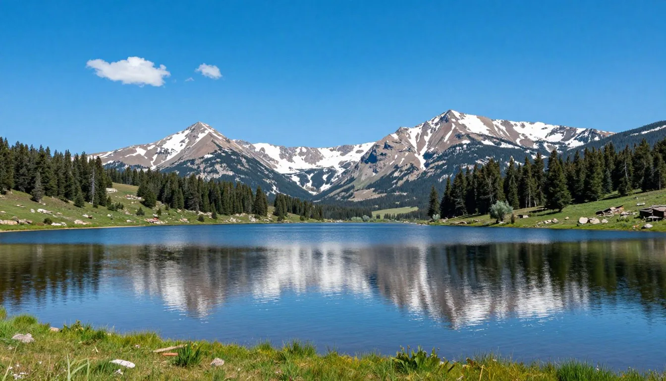
Mount Oxford rises majestically in the Collegiate Peaks Wilderness of central Colorado. The mountain shares its ridgeline with Mount Belford, creating one of the most popular double-summit hikes in the state. These twin peaks offer hikers stunning alpine scenery, manageable class two terrain, and an unforgettable high-altitude experience.
Whether you dream of standing atop your first 14er or adding another peak to your summit log, Mount Oxford delivers an incredible mountain adventure. This comprehensive guide covers everything you need to plan your trip, from trail routes and weather patterns to nearby accommodations and dining options.
Getting There & Planning Your Journey
Mount Oxford sits in Chaffee County, approximately 257 km (160 miles) southwest of Denver. The Missouri Gulch Trailhead serves as the primary starting point for summit attempts. Most visitors fly into Denver International Airport, the closest major hub, located about three hours away by car.
From Denver, take Interstate 70 west to Highway 24 south through Leadville. Continue to Highway 82 west toward Aspen, then turn north on County Road 390 (Vicksburg Road). The final stretch requires a high-clearance vehicle as the road becomes rough and rocky near the trailhead.
Colorado Springs Airport offers another option, situated 209 km (130 miles) southeast of the mountain. This smaller airport sometimes provides better deals but requires a slightly longer drive through Buena Vista.
Trailhead Access Details
The Missouri Gulch Trailhead sits at 2,896 m (9,500 feet) elevation. Standard sedans can typically reach the lower parking area at mile 1.5 of County Road 390. A rough, rocky road continues another 2.4 km (1.5 miles) to the upper trailhead, accessible only to high-clearance, four-wheel-drive vehicles.
Parking fills quickly during peak season, often by 6:00 AM on summer weekends. Arrive before sunrise to secure a spot and start your hike early. The lower parking area accommodates overflow when the upper lot reaches capacity.

Permits and Regulations
No permits are required to hike Mount Oxford. The trail passes through San Isabel National Forest and the Collegiate Peaks Wilderness. Wilderness regulations apply, including group size limits of 12 people and mandatory pack-in, pack-out waste policies.
Dogs are permitted on the trail but must remain under voice control or on leash. Consider your pet’s fitness level carefully, as the route gains over 1,372 m (4,500 feet) of elevation and covers challenging rocky terrain.
Best Time to Visit & Weather Tips
Timing your Mount Oxford adventure correctly makes the difference between a memorable summit and a dangerous situation. Weather conditions change rapidly at high elevation, and seasonal variations dramatically affect trail accessibility and safety.
Recommended Visiting Seasons
Late June through early September offers the best weather window for summiting Mount Oxford. Snow typically melts from the trail by mid-June, though patches may linger in shaded areas. This summer season provides the most stable weather patterns and safest conditions.
July and August represent peak hiking months. Temperatures at the trailhead range from 10°C to 21°C (50°F to 70°F) during daylight hours. Summit temperatures drop significantly, often hovering around 2°C to 10°C (35°F to 50°F) even on warm summer days.
Check 30,000+ Local Sightseeing Tours Worldwide
✓ Numerous languages and currencies are available
Best Months to Visit
These months provide optimal conditions for hiking Mount Oxford with minimal weather risks and accessible trails.
- July – Most stable weather, warmest temperatures, longest daylight hours
- August – Continued good weather, wildflowers peak, reliable conditions
- Early September – Fewer crowds, cooler temps, beautiful fall colors begin
- Late June – Trail opens, fewer hikers, some snow patches possible
Months to Avoid
These periods present significant challenges and safety concerns for most hikers attempting Mount Oxford.
- November through May – Heavy snow, avalanche danger, extreme cold, impassable roads
- October – Early winter storms, unpredictable conditions, very cold summits
- Early June – Deep snowpack, difficult route finding, increased avalanche risk
- Late September – Winter weather can arrive suddenly with little warning
Daily Weather Patterns
Mountain weather follows predictable daily patterns during summer months. Mornings typically start clear and calm, with clouds building through late morning. Afternoon thunderstorms develop frequently, especially in July and August, bringing lightning, hail, and heavy rain.
Start your hike before dawn to reach the summit by noon. This timing allows you to descend below treeline before afternoon storms arrive. Lightning poses the most serious weather threat on exposed ridges and summits.

What to Expect Each Season
Summer brings warm days but cold mornings, with temperatures at the trailhead starting near freezing. Pack layers to adjust as temperatures rise during your ascent. Afternoon thunderstorms occur almost daily during peak summer weeks.
Early fall offers fewer crowds and stunning golden aspen displays in surrounding valleys. However, the chance of snow increases significantly after mid-September. Winter conditions make the route extremely dangerous for all but the most experienced mountaineers with proper equipment.
Getting Around Locally
The Mount Oxford area requires personal transportation. No public transit serves the trailhead or surrounding mountain communities. Rental cars from Denver or Colorado Springs airports provide the most practical access.
Vehicle Requirements
A high-clearance vehicle significantly improves your experience. The final 2.4 km (1.5 miles) to the upper Missouri Gulch Trailhead requires navigating large rocks and deep ruts. Four-wheel drive capability allows you to start your hike 45 minutes closer to the summit.
Standard cars can reach the lower parking area without difficulty. This adds approximately 4.8 km (3 miles) round trip and 152 m (500 feet) of elevation gain to your overall hike. Many visitors consider this acceptable given rental vehicle costs and insurance concerns.
Nearby Towns and Services
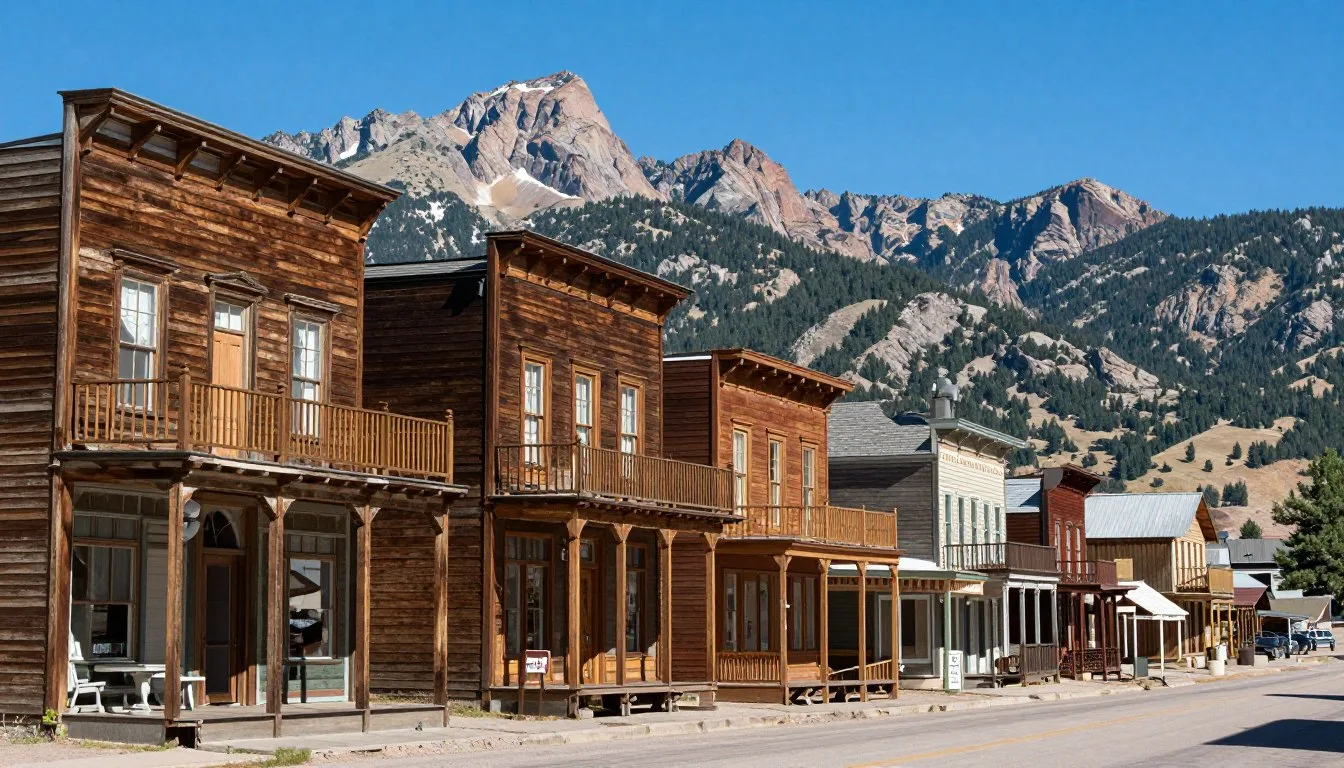
Buena Vista, located 29 km (18 miles) south of the trailhead, serves as the closest full-service town. This charming mountain community offers grocery stores, outdoor gear shops, restaurants, and various lodging options. Stock up on supplies here before heading to the trail.
Leadville lies 48 km (30 miles) north and provides another option for services and accommodations. This historic mining town sits at 3,094 m (10,152 feet) elevation, making it useful for acclimatization before your summit attempt.

Where to Stay
Lodging options near Mount Oxford range from rustic campgrounds to comfortable hotels. Your choice depends on budget, desired amenities, and how close you want to stay to the trailhead.
Camping Near the Trailhead
Dispersed camping is permitted along County Road 390 below the Missouri Gulch Trailhead. These free, primitive sites offer the shortest drive to your morning start. Arrive early to claim a spot during busy summer weekends. Sites lack facilities but put you closest to the trail.
Clear Creek Reservoir Campground provides developed camping 19 km (12 miles) from the trailhead. This Forest Service facility offers vault toilets, picnic tables, and stunning reservoir views. The campground operates on a first-come, first-served basis from June through September.
Hotels and Lodges
Buena Vista hosts numerous hotels, motels, and vacation rentals. Popular chains and independent properties provide comfortable rooms with hot showers and restaurants nearby. Staying in town adds 45 minutes to your morning drive but offers more amenities.
Several bed and breakfast establishments in Buena Vista cater specifically to hikers. These properties offer early breakfast options, packed lunches, and knowledgeable hosts who provide current trail conditions and weather advice.

Acclimatization Considerations
Spending at least one night at elevation before your hike reduces altitude sickness risk. The Missouri Gulch Trailhead sits at 2,896 m (9,500 feet), and the summit reaches 4,272 m (14,153 feet). This significant elevation gain affects most people arriving from lower altitudes.
Buena Vista rests at 2,408 m (7,900 feet) elevation, providing a good intermediate height for adjustment. Consider arriving two days before your planned summit attempt to allow your body time to adapt to the thinner air.
Dining & Local Cuisine
The Mount Oxford area offers limited dining options at the trailhead itself, but nearby Buena Vista provides excellent restaurants and cafes. Plan to pack trail food and prepare for dining before or after your hike in town.
Pre-Hike Breakfast Options
Several Buena Vista cafes open early to serve hikers heading to the peaks. Expect hearty breakfast burritos, oatmeal, eggs, and strong coffee to fuel your adventure. Many establishments understand 14er schedules and accommodate 5:00 AM dining needs during summer months.
Stock up on trail snacks at local grocery stores. High-energy foods like nuts, dried fruit, energy bars, and jerky provide essential calories during your long summit day. Bring more food than you think necessary, as appetite increases at altitude.
Post-Hike Dining
After descending from Mount Oxford, Buena Vista restaurants offer everything from casual pub food to upscale dining. Local breweries serve craft beer perfect for celebrating your summit success. Many hikers crave burgers, pizza, and other hearty meals after burning thousands of calories on the mountain.
Mexican restaurants in the area provide generous portions and flavorful dishes. Try authentic green chili, a Colorado specialty that warms tired muscles. Several establishments feature outdoor patios with mountain views where you can relax and recount your adventure.

What to Pack for the Trail
Bring at least three liters of water per person for the hike. The route offers no reliable water sources above the trailhead. Dehydration occurs quickly at high elevation, especially during physical exertion.
Pack calorie-dense snacks you enjoy eating. Altitude often suppresses appetite, but maintaining energy intake proves crucial for summit success and safe descent. Include electrolyte supplements to replace minerals lost through sweat.
Attractions, Sightseeing & Activities
Mount Oxford itself serves as the primary attraction, but the surrounding area offers numerous activities and sights for multi-day visits. The Collegiate Peaks region ranks among Colorado’s most spectacular mountain landscapes.
The Mount Belford and Mount Oxford Loop
Most hikers combine Mount Oxford with Mount Belford in a challenging but rewarding loop. This classic route covers approximately 16 km (10 miles) round trip with 1,509 m (4,950 feet) of elevation gain. Plan for eight to twelve hours to complete both peaks.
The standard route climbs Missouri Gulch to Mount Belford first, then traverses the ridge to Mount Oxford. Some hikers reverse this order based on personal preference. The saddle between peaks offers stunning views and a chance to rest before tackling the second summit.

Summit Experience
Standing atop Mount Oxford rewards hikers with 360-degree views of the Collegiate Peaks Wilderness. On clear days, visibility extends for over 160 km (100 miles). Identify neighboring 14ers including Harvard, Columbia, and the Apostles from the rocky summit.
The summit plateau provides space for groups to rest, eat, and take photos. A small cairn marks the highest point. Strong winds frequently blow across the exposed peak, so bring extra layers even on warm days.
Wildlife Viewing
The Mount Oxford trail passes through prime wildlife habitat. Mountain goats often appear on rocky slopes above treeline. These agile animals show little fear of humans but should never be approached or fed.
Elk frequent the lower portions of Missouri Gulch during summer months. Watch for marmots and pikas among boulder fields. Birds of prey soar overhead, riding thermal currents above the peaks. Carry binoculars for better wildlife observation.

Wildflower Season
July and early August bring spectacular wildflower displays to Missouri Gulch and the slopes of Mount Oxford. Columbines, paintbrush, alpine sunflowers, and dozens of other species carpet the meadows below treeline in vibrant colors.
The brief alpine growing season creates concentrated blooms that transform the landscape. Photography enthusiasts find endless subjects during peak wildflower weeks. Morning light provides the best conditions for capturing these delicate mountain flowers.
Museums, Cultural Spots & Festivals
While Mount Oxford itself offers purely natural attractions, nearby communities host several cultural venues and events worth exploring during your visit. These activities complement your mountain adventures with local history and mountain culture.
Buena Vista Heritage Museum
This small museum in downtown Buena Vista showcases the area’s mining and railroad history. Exhibits include artifacts from the region’s boom years when prospectors flooded the Arkansas Valley seeking fortune. The museum occupies a historic courthouse building and offers insights into life in early Colorado mountain towns.
Admission remains affordable, and volunteer docents share stories about local pioneers. The museum typically opens afternoons during summer months. Call ahead to confirm hours, as schedules vary seasonally.
Local Art Galleries
Buena Vista hosts several art galleries featuring mountain landscapes, wildlife paintings, and sculptures by Colorado artists. These spaces showcase the region’s creative community and offer unique souvenirs. Many galleries display works inspired by the Collegiate Peaks visible from town.
Summer brings outdoor art shows and festivals to the town center. Local craftspeople sell handmade goods, jewelry, and photography. These events create lively atmospheres perfect for evening strolls after hiking.

Seasonal Events
The GoPro Mountain Games take place annually in nearby Vail, celebrating outdoor sports and adventure culture. This multi-day festival includes climbing competitions, trail running races, kayaking events, and vendor expos. The June timing coincides with the opening of high-elevation hiking trails.
Buena Vista hosts smaller summer festivals celebrating everything from music to craft beer. Check local event calendars when planning your trip. These gatherings provide opportunities to meet fellow outdoor enthusiasts and experience mountain town culture.
Nature & Outdoor Experiences
Beyond summiting Mount Oxford, the surrounding Collegiate Peaks Wilderness and Arkansas Valley offer countless outdoor recreation opportunities. Multi-day visits allow exploration of diverse terrain from river valleys to alpine ridges.
Additional 14er Peaks
Mount Oxford stands as just one of 15 fourteen-thousand-foot peaks in the Collegiate Peaks range. Nearby Mount Harvard, Mount Columbia, and Mount Princeton offer similar challenges for peak baggers. Each mountain presents unique characteristics and varying difficulty levels.
Some hikers spend entire summers working through the Collegiate Peaks collection. These mountains provide excellent training for more technical climbs elsewhere in Colorado. The relatively moderate class two and class three routes make them accessible to fit hikers with proper preparation.
White Water Rafting
The Arkansas River flows through Buena Vista, creating some of Colorado’s premier whitewater rafting. Commercial outfitters offer half-day and full-day trips through various sections of the river. Rapids range from family-friendly class two to intense class four challenges.
Browns Canyon National Monument protects 34 km (21 miles) of the Arkansas River corridor. This section features spectacular scenery combining rushing water with towering canyon walls. Spring snowmelt creates the highest water levels and most exciting conditions.

Mountain Biking
Hundreds of miles of mountain bike trails crisscross the mountains and valleys surrounding Mount Oxford. Routes range from gentle dirt roads to technical singletrack. The Monarch Crest Trail ranks among Colorado’s most scenic high-altitude rides, traversing the Continental Divide.
Buena Vista bike shops offer rentals, repairs, and trail recommendations. Guided tours provide options for riders unfamiliar with local trails. Many routes climb to elevations exceeding 3,353 m (11,000 feet), so acclimatization matters for cycling as much as hiking.
Fishing Opportunities
Clear Creek and other mountain streams near Mount Oxford harbor wild trout populations. Colorado Parks and Wildlife manages these waters for quality fishing experiences. Proper licenses and knowledge of regulations prove essential before casting a line.
High mountain lakes accessible via hiking trails offer remote fly fishing in spectacular settings. These backcountry destinations require more effort to reach but reward anglers with solitude and pristine waters. Native cutthroat trout inhabit many streams above 2,743 m (9,000 feet).
Rock Climbing
The Collegiate Peaks region includes numerous rock climbing areas. Granite cliffs near Buena Vista feature sport and traditional routes across all difficulty grades. Local climbing guidebooks detail hundreds of established routes.
Experienced climbers attempt technical routes on 14er faces during summer months. These alpine climbs require mountaineering skills and proper equipment. Guide services in Buena Vista offer instruction and guided climbs for those seeking expert leadership.

Safety, Etiquette & Local Customs
Mountain safety requires preparation, knowledge, and good judgment. Understanding potential hazards and proper wilderness etiquette protects both you and the pristine environment you came to enjoy.
Essential Safety Considerations
Altitude sickness affects many hikers attempting Mount Oxford. Symptoms include headache, nausea, dizziness, and fatigue. Descend immediately if symptoms worsen despite rest and hydration. Spending time at elevation before your summit attempt significantly reduces risk.
Lightning presents the most serious weather hazard on exposed peaks. If thunderstorms threaten, retreat below treeline immediately. Avoid summits, ridges, and isolated trees. The afternoon storm pattern makes early morning starts crucial for safety.
Emergency Contact Information: Cell phone coverage exists sporadically along the Mount Oxford trail. Download offline maps before leaving cell service. The nearest hospital operates in Buena Vista, approximately 45 minutes from the trailhead. For emergencies, call 911. Chaffee County Search and Rescue responds to mountain incidents.
What to Bring for Safety
Pack the ten essentials for every mountain hike: navigation tools, sun protection, extra clothing, illumination, first aid supplies, fire starter, repair kit, nutrition, hydration, and emergency shelter. Weather changes rapidly at high elevation, turning pleasant conditions dangerous within minutes.
Bring more warm clothing than seems necessary. Summit temperatures can be 17°C (30°F) colder than at the trailhead. Wind chill amplifies the cold effect. Hypothermia occurs even during summer months on Colorado peaks.
- Layered clothing system with insulating and waterproof options
- Hat, gloves, and warm layers for summit conditions
- Sturdy hiking boots with ankle support and aggressive tread
- Trekking poles to reduce knee strain on steep descent
- Headlamp with extra batteries for pre-dawn starts
- Sun protection including sunscreen, sunglasses, and lip balm
- First aid kit including blister treatment and pain relievers
- Emergency shelter like a lightweight bivy or space blanket
Trail Etiquette and Wilderness Ethics
Practice Leave No Trace principles throughout your visit. Pack out all trash, including food scraps and toilet paper. Stay on established trails to prevent erosion and protect fragile alpine vegetation. One wrong step off-trail can destroy plants that took decades to grow.
Uphill hikers have right of way on narrow trail sections. Step aside to let ascending parties pass without breaking their rhythm. Greet fellow hikers with a friendly hello. The mountain community thrives on mutual respect and shared appreciation for the peaks.

Wildlife Safety
Mountain goats sometimes approach hikers seeking salt and minerals. Never feed wildlife or allow them to lick your backpack, clothing, or hands. Feeding animals habituates them to humans and creates dangerous situations. Keep food stored securely.
Black bears inhabit forests surrounding Mount Oxford, though encounters remain rare at high elevations. Make noise while hiking through dense vegetation. If you encounter a bear, remain calm, speak in a normal voice, and slowly back away. Never run from a bear.
Physical Preparedness
Mount Oxford requires solid physical fitness. The route gains over 1,372 m (4,500 feet) of elevation across rough, rocky terrain. Train for several months before attempting your first 14er. Build cardiovascular endurance and leg strength through hiking, running, or stair climbing.
Know your limits and turn back if conditions exceed your abilities. Summiting always remains optional, but descending safely is mandatory. Many experienced mountaineers have turned around short of their goal when conditions deteriorate or energy runs low.
Visitor Comments About Mount Oxford
Hikers who have summited Mount Oxford share their experiences and insights. These perspectives from fellow adventurers provide valuable real-world context for planning your own trip.
“Mount Oxford exceeded every expectation. The views from the summit took my breath away, literally and figuratively. The ridge walk between Belford and Oxford felt like walking on top of the world. Start early to beat the crowds and weather. The effort was absolutely worth it.”
Check 30,000+ Local Sightseeing Tours Worldwide
✓ Numerous languages and currencies are available
“I underestimated the difficulty of the final push to Oxford’s summit. The loose rock and steep switchbacks challenged my legs after already summiting Belford. Take your time and stay hydrated. The sunrise from the saddle between peaks created a memory I’ll treasure forever. This hike pushed me to my limits in the best possible way.”
“Mount Oxford was my first Colorado 14er, and it set the bar high. The Missouri Gulch approach seemed endless, but each step revealed more stunning scenery. I appreciated how well-marked the trail remained even above treeline. The summit cairn felt like the culmination of months of training. Already planning my return to tackle more peaks in this incredible range.”
Additional Nearby Destinations
The Mount Oxford area serves as an excellent base for exploring central Colorado’s mountain landscapes. Several worthwhile destinations lie within easy driving distance, perfect for rest days or extending your adventure.
Cottonwood Pass
This scenic mountain pass reaches 3,689 m (12,126 feet) elevation, cresting the Continental Divide between Buena Vista and Gunnison. The paved road climbs through aspen forests before emerging onto alpine tundra with sweeping views. Several hiking trails branch from the pass, including routes to nearby peaks.
The Cottonwood Pass road typically opens in late May or early June after winter snow removal. Fall brings golden aspen colors that attract photographers from across Colorado. The pass makes an excellent acclimatization drive before attempting Mount Oxford.

Leadville Historic District
America’s highest incorporated city sits at 3,094 m (10,152 feet) in elevation. Leadville’s Victorian-era downtown preserves buildings from the silver mining boom of the 1880s. Museums tell stories of famous residents including Baby Doe Tabor and Doc Holliday.
The National Mining Hall of Fame and Museum showcases mining history and technology. Downtown restaurants serve hearty meals perfect for fueling mountain adventures. Leadville makes an interesting cultural stop before or after hiking Mount Oxford.
Collegiate Peaks Scenic Byway
This 93 km (58 mile) driving route follows Highway 24 through the Arkansas River Valley between Leadville and Buena Vista. The byway provides stunning views of multiple 14ers including Mount Oxford, Mount Harvard, and Mount Princeton.
Numerous pullouts allow photo stops and wildlife viewing. The route passes hot springs, historic sites, and trailheads. Allow two to three hours for the complete drive with stops. The scenic byway offers excellent opportunities to scout peaks for future climbs.
Mount Princeton Hot Springs
Natural hot springs flow from Mount Princeton’s slopes, creating several soaking pools. A commercial resort operates the main developed pools, while free primitive pools exist along Chalk Creek. The hot mineral water soothes tired muscles after hiking Mount Oxford.
Day use fees provide access to multiple pools ranging from 32°C to 41°C (90°F to 105°F). The resort also offers overnight accommodations and dining. Arrive early during summer weekends as the pools attract crowds. The drive from Mount Oxford takes approximately 40 minutes.

Aspen and Snowmass
These famous resort towns sit approximately 80 km (50 miles) west of Mount Oxford via Independence Pass. Aspen offers upscale dining, shopping, and cultural attractions. Summer brings festivals, concerts, and hiking opportunities in the Maroon Bells-Snowmass Wilderness.
The drive over Independence Pass crosses the Continental Divide at 3,687 m (12,095 feet). This spectacular route typically opens in late May and closes in November. Aspen makes a worthwhile day trip for those seeking amenities beyond small mountain towns.
Practical Travel Tips
Successfully planning and executing a Mount Oxford adventure requires attention to numerous details. These practical tips help ensure your experience goes smoothly from planning through summit and return.
Fitness and Training
Begin training at least eight weeks before attempting Mount Oxford. Focus on cardiovascular conditioning and leg strength. Hike regularly with a weighted backpack to simulate trail conditions. Stair climbing builds specific muscles needed for long ascents and descents.
If you live at low elevation, arrive in Colorado several days early for acclimatization. Sleep at moderate altitude before attempting the summit. Proper acclimatization dramatically improves your chances of success and reduces discomfort from altitude sickness.
Budgeting Your Trip
A basic Mount Oxford trip costs relatively little compared to other mountain vacations. Gas, camping fees (if applicable), and food represent the main expenses. Budget travelers can complete a three-day trip for a few hundred dollars excluding airfare.
Guided trips cost significantly more but provide expert leadership and reduce planning stress. Professional guide services typically charge several hundred dollars per person for 14er climbs. This investment makes sense for inexperienced hikers concerned about safety and route-finding.
Typical Trip Costs
- Round-trip flights from major cities: Variable depending on advance purchase and season
- Rental car for four days: Varies by vehicle type and company
- Hotel in Buena Vista per night: Mid-range to budget options available
- Camping fees: Free dispersed camping or minimal fee at developed campgrounds
- Meals and groceries: Budget for dining out and trail food
- Guided climb (optional): Professional guide services available
- Gear purchases: If acquiring new equipment
Money-Saving Tips
- Visit during shoulder season for lower accommodation rates
- Camp instead of staying in hotels to reduce lodging costs
- Prepare your own meals rather than dining out frequently
- Borrow or rent gear instead of purchasing new equipment
- Travel with a group to split transportation and camping costs
- Book flights and rentals well in advance for better rates
- Use free dispersed camping near the trailhead when possible
What to Pack
Create a detailed packing list several weeks before departure. Test all gear during training hikes to ensure proper fit and function. Breaking in new boots before your summit attempt prevents painful blisters that can end your hike prematurely.
Pack layers that can be added or removed as conditions change. Avoid cotton clothing, which loses insulating properties when wet. Synthetic and wool materials maintain warmth even in damp conditions. A waterproof jacket and pants protect against sudden storms.
Communication and Navigation
Download offline maps to your smartphone before losing cell service. Several apps provide detailed topographic maps that work without internet connection. Carry a paper map and compass as backup navigation tools. GPS devices require fresh batteries or full charge.
Inform someone of your hiking plans including expected return time. Provide vehicle description and parking location. This information helps search and rescue if you fail to return as scheduled. Check in by phone or text after descending safely.
Photography Tips
Morning light provides the best conditions for mountain photography. Golden hour illuminates peaks beautifully shortly after sunrise. Bring extra camera batteries as cold temperatures drain power quickly. Protect electronics from moisture and impacts in padded cases.
Capture the journey, not just the summit. Photograph wildflowers, wildlife, hiking companions, and scenic vistas along the trail. These images tell a more complete story than summit photos alone. Sunrise and sunset create dramatic lighting on surrounding peaks.

Environmental Responsibility
Practice Leave No Trace principles rigorously. Pack out everything you pack in, including food scraps and hygiene products. Human waste should be buried at least 15 cm (6 inches) deep and 61 m (200 feet) from water sources. Better yet, pack out solid waste using WAG bags.
Stay on established trails to prevent erosion and protect alpine vegetation. Shortcutting switchbacks causes lasting damage to fragile tundra plants. These high-altitude species grow extremely slowly and recover poorly from trampling. Your careful footsteps help preserve this wilderness for future visitors.
Your Mount Oxford Adventure Awaits
Mount Oxford stands ready to challenge and inspire you with its stunning beauty and rewarding summit. This magnificent 14er offers accessible adventure in one of Colorado’s most spectacular mountain ranges. Whether you tackle Oxford alone or combine it with Mount Belford for an epic double-peak day, the memories created on these summits last a lifetime.
The trails await your footsteps. Clear mountain air beckons you higher. Endless views from the summit reward every challenging step of the climb. Start planning your Mount Oxford adventure today and discover why thousands of hikers return year after year to experience the magic of Colorado’s high peaks.
The mountains are calling. Will you answer?