Hotels by Trip.com
Flights by Trip.com
Mount Zirkel Wilderness protects more than 160,000 acres of pristine alpine terrain, making it the second-largest wilderness area in Colorado. Yet fewer than 15,000 visitors explore these rugged peaks each year, compared to millions who crowd Rocky Mountain National Park just 100 miles southeast.
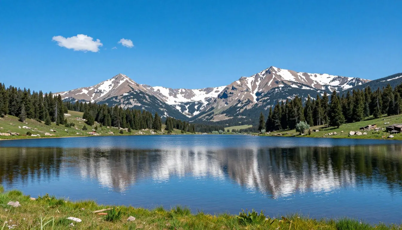
This stunning wilderness offers something extraordinary. Towering peaks reach above 12,180 feet into crystalline skies. Alpine lakes shimmer like scattered jewels across high meadows. Ancient spruce forests shelter elk herds and mountain wildlife.
The area remains refreshingly uncrowded despite its incredible beauty. You can hike for miles without encountering another soul. Crystal-clear streams cascade down granite slopes. Wildflower meadows explode with color each summer.
Mount Zirkel stands as the crown jewel of this wilderness. The mountain dominates the skyline at 3,712 meters or 12,180 feet. Its distinctive profile has guided travelers through the Park Range for generations.
This comprehensive guide reveals everything you need to know. We share insider tips for planning your journey. You’ll discover the best trails, camping spots, and seasonal highlights. Safety advice and local wisdom ensure your adventure succeeds.
Getting There and Planning Your Journey
Yampa Valley Regional Airport in Hayden serves as the closest air gateway to Mount Zirkel Wilderness. The airport sits just 35 kilometers or 22 miles west of Steamboat Springs. Major airlines offer seasonal service from hub cities across the United States.
Denver International Airport provides year-round accessibility with extensive flight options. The drive from Denver takes approximately three hours covering 253 kilometers or 157 miles. The scenic route travels through mountain valleys and historic mining towns.

Eagle County Regional Airport in Gypsum offers another alternative. This facility lies 145 kilometers or 90 miles south of Steamboat Springs. Winter ski traffic keeps this airport particularly busy during peak season.
Key Planning Contacts
Medicine Bow-Routt National Forests Supervisor’s Office provides essential wilderness information and current trail conditions.
Rental vehicles become necessary for wilderness access. Steamboat Springs offers the nearest services and supplies. The town provides full amenities including grocery stores, outdoor gear shops, and fuel stations.
Multiple trailheads access Mount Zirkel Wilderness from the Steamboat Springs area. Forest roads lead to popular starting points like Slavonia and Buffalo Pass. High-clearance vehicles handle rough access roads better during spring and fall.
Wilderness permits are not required for day hiking. Overnight camping follows Leave No Trace principles without formal permits. Rangers appreciate voluntary trip registration for safety purposes.
Check 30,000+ Local Sightseeing Tours Worldwide
✓ Numerous languages and currencies are available
Best Time to Visit and Weather Tips
Best Time to Visit Mount Zirkel Wilderness
Summer delivers the most reliable wilderness access from late June through September. Snowpack melts from high elevation trails by mid-July in typical years. Wildflowers peak during July and early August across alpine meadows.
Fall transforms the wilderness into a photographer’s paradise. Aspen groves turn brilliant gold against evergreen forests from mid-September through early October. Cooler temperatures bring fewer insects and clearer skies. Elk bugling echoes through valleys during September.
Recommended Seasons
- July through August for high alpine hiking and wildflowers
- September for fall colors and comfortable temperatures
- Late June and early October for solitude with some weather risk
- January through March for winter backcountry skiing
Seasons to Avoid
- April through mid-June due to deep snowpack and avalanche danger
- Late October through December when early winter storms arrive
- Mid-summer afternoons during peak lightning season
Winter adventurers find exceptional backcountry opportunities. Deep snow buries trails from November through May. Experienced skiers and snowshoers explore the frozen wilderness. Extreme cold and avalanche hazards demand proper preparation.
Weather Patterns and Preparation
Mountain weather changes rapidly at high elevation. Morning sunshine often gives way to afternoon thunderstorms during summer months. Lightning poses serious danger above treeline after noon.

Summer daytime temperatures range from 15°C to 24°C or 60°F to 75°F in valleys. Temperatures drop significantly at higher elevations. Nights cool to near freezing even in July at alpine campsites.
Fall weather becomes increasingly unpredictable. September typically offers stable conditions with highs around 18°C or 65°F. October brings the first significant snowstorms. Overnight lows frequently dip below freezing.
Weather Safety Tip: Start alpine hikes before dawn to reach summits by late morning. Afternoon thunderstorms develop quickly above treeline. Descend to lower elevations by early afternoon during peak lightning season.
Winter temperatures plunge well below zero. Daytime highs hover around -7°C to -1°C or 20°F to 30°F. Nighttime temperatures drop to -23°C or -10°F regularly. Wind chill creates dangerous conditions on exposed ridges.
Notable Annual Festivals
Steamboat Springs hosts numerous festivals celebrating mountain culture. These events bring the community together throughout the year. Visitors experience authentic Colorado mountain traditions.
Winter Carnival runs each February for more than 100 years. The celebration features ski jumping competitions, street events, and the famous Lighted Man descent. Locals and visitors crowd downtown streets for parades and activities.

MusicFest brings classical music to the mountains each summer. Concerts echo through Strings Music Pavilion from late June through August. World-class musicians perform against stunning mountain backdrops.
Festival Information Contact
Steamboat Springs Chamber Resort Association coordinates event details and provides current festival schedules.
Steamboat Wine Festival takes place each January. Wine enthusiasts sample premium vintages while enjoying mountain views. The event raises funds for local charities and scholarships.
Hot Air Balloon Rodeo launches colorful balloons each July. Dozens of balloons drift over Yampa Valley in early morning flights. The spectacle attracts photographers and families alike.
Getting Around Locally
Personal vehicles provide essential transportation for wilderness access. Public transit does not reach trailheads or remote areas. Steamboat Springs offers the only significant services within reasonable distance.
Forest Service roads require attention to current conditions. Spring runoff damages roads with washouts and erosion. Summer maintenance improves access gradually. Fall weather brings early snow to high elevation routes.
Steamboat Springs Transit (SST) operates free bus service within town limits. Routes connect lodging areas with downtown shops and restaurants. Service runs year-round with extended hours during ski season.
Buffalo Pass Road provides critical access to wilderness trailheads. The route climbs from Steamboat Springs to multiple hiking starting points. Passenger cars manage the drive during dry summer months. Snow closes the road from October through June.

Bike rentals offer enjoyable transportation around Steamboat Springs. The Yampa River Core Trail spans 11 kilometers or 7 miles through town. Paved pathways connect parks, shopping areas, and residential neighborhoods.
Taxi services and ride-sharing operate within Steamboat Springs. Limited availability affects service during peak seasons. Advance booking ensures reliable transportation for early morning trailhead departures.
Where to Stay
Steamboat Springs provides the primary lodging base for wilderness visitors. The town offers accommodations ranging from budget motels to luxury resorts. Most properties sit within 32 kilometers or 20 miles of major trailheads.
Hotels and Resorts
Sheraton Steamboat Resort anchors the mountain village area. The property features slope-side access during winter and mountain views year-round. Guests enjoy pools, hot tubs, and multiple dining options.
Hampton Inn & Suites serves budget-conscious travelers near downtown. The hotel includes complimentary breakfast and modern amenities. Its location provides easy access to restaurants and shops.
Lodging Assistance
Steamboat Springs Lodging provides comprehensive accommodation booking services and seasonal package deals.
Vacation Rentals and Cabins
Private homes and condos scatter throughout Steamboat Springs. These rentals accommodate groups and families seeking full kitchens. Properties range from simple condos to luxurious mountain estates.
Historic downtown features charming Victorian-era homes converted to lodging. Walking distance to restaurants and nightlife makes these properties popular. Many retain original architectural details and character.

Camping Options
Developed campgrounds surround the wilderness boundary. Dry Lake Campground sits near Seedhouse Road at 2,743 meters or 9,000 feet elevation. The facility offers 8 sites with basic amenities from June through September.
Dispersed camping follows Leave No Trace ethics throughout national forest lands. Free camping exists along forest roads outside wilderness boundaries. Popular spots fill quickly on summer weekends.
Backcountry camping within Mount Zirkel Wilderness requires no permits. Established sites minimize impact around popular lakes. Campers must stay at least 30 meters or 100 feet from water sources.
Dining and Local Cuisine
Steamboat Springs restaurants emphasize fresh ingredients and Western hospitality. The dining scene blends mountain traditions with contemporary culinary trends. Options satisfy every taste and budget level.
Casual Mountain Dining
Backdoor Grille & Tap House serves hearty burgers and craft beers. The casual atmosphere welcomes hikers returning from wilderness adventures. Outdoor seating overlooks downtown streets during summer months.
Taco Cabo satisfies Mexican food cravings with fresh preparation. Generous portions and reasonable prices attract locals and visitors alike. The restaurant bustles during lunch and early dinner hours.

Upscale Dining Experiences
Truffle Pig serves innovative small plates and craft cocktails. The intimate space features locally sourced ingredients and creative presentations. Reservations become essential during peak seasons.
Laundry Kitchen & Cocktails occupies a renovated historic building downtown. The menu changes seasonally highlighting Colorado producers. Thoughtful wine pairings complement contemporary American cuisine.
Breakfast and Coffee
Winona’s serves legendary breakfast to early risers and late brunchers. The restaurant cranks out enormous portions of classic American breakfast. Expect waits on weekend mornings during busy seasons.
Lava Café roasts coffee beans on-site for exceptional espresso drinks. The shop offers light breakfast options and fresh pastries. Outdoor seating provides prime people-watching opportunities downtown.
Local Favorite: Sample Steamboat’s famous champagne powder snow cone dessert at local ice cream shops. The treat takes its name from the area’s legendary dry snow conditions.
Mountain market delis prepare trail lunches for wilderness adventures. Order sandwiches and snacks the night before early hiking departures. Several grocery stores stock camping supplies and freeze-dried meals.
Attractions, Sightseeing, and Activities
Hiking Mount Zirkel
The summit of Mount Zirkel challenges experienced hikers with a demanding ascent. The standard route covers approximately 20 kilometers or 12.5 miles round trip. Elevation gain totals roughly 975 meters or 3,200 feet from Gold Creek Lake trailhead.
Hikers typically start before dawn to avoid afternoon thunderstorms. The trail climbs steadily through dense forest before emerging at treeline. Alpine tundra leads to the final scramble across rocky slopes.

Summit views span the entire Park Range and beyond. Clear days reveal peaks stretching into Wyoming to the north. The Continental Divide carves a dramatic line across the eastern horizon.
Gold Creek Lake
Gold Creek Lake sits cradled in a cirque below Mount Zirkel’s eastern face. The pristine alpine lake covers approximately 8 hectares or 20 acres. Crystal-clear water reflects surrounding peaks on calm mornings.
The hike to Gold Creek Lake extends 11 kilometers or 7 miles one way from the trailhead. Moderate elevation gain makes this route accessible to intermediate hikers. Wildflowers carpet meadows along the creek in mid-summer.
Camping near Gold Creek Lake offers front-row seats to mountain sunrise. Established sites minimize impact on fragile alpine vegetation. Cold nights require warm sleeping bags even in summer months.
Zirkel Circle Loop
The Zirkel Circle Loop ranks among Colorado’s premier backpacking routes. This demanding circuit covers approximately 48 kilometers or 30 miles through the heart of the wilderness. Most hikers complete the loop in three to four days.

The route passes numerous alpine lakes including Gilpin Lake and Red Dirt Pass. Each campsite reveals new perspectives on the rugged mountain landscape. Stream crossings require caution during spring runoff periods.
Trail elevation varies from 2,743 meters to 3,353 meters or 9,000 feet to 11,000 feet. Proper acclimatization prevents altitude sickness for lowland visitors. Physical conditioning ensures enjoyment rather than suffering.
Gilpin Lake
Gilpin Lake attracts anglers seeking native cutthroat trout. The remote location ensures light fishing pressure compared to roadside waters. Colorado fishing licenses and current regulations apply to all wilderness waters.
The lake occupies a scenic basin surrounded by towering peaks. Camping spots overlook turquoise waters from nearby ridges. Sunset alpenglow paints cliffs in brilliant orange and pink hues.
Museums, Cultural Spots, and Festivals
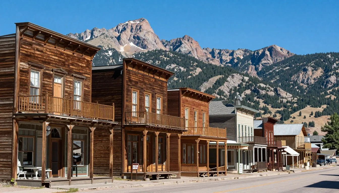
Steamboat Springs celebrates rich ranching and skiing heritage through various cultural venues. Museums preserve the region’s transformation from cattle country to mountain resort. Authentic Western culture remains alive in modern times.
Tread of Pioneers Museum
The Tread of Pioneers Museum chronicles Steamboat Springs history from indigenous peoples through modern times. Exhibits showcase ranching equipment, skiing evolution, and pioneer life. The museum occupies a historic building downtown.

Collections include photographs documenting the area’s development. Historic ski equipment demonstrates how the sport evolved over decades. Rotating exhibits highlight specific aspects of local heritage.
Art Galleries and Studios
Gallery 4040 features contemporary Western art from regional artists. Paintings, sculptures, and photography capture mountain landscapes and wildlife. The gallery hosts opening receptions showcasing new works.
Steamboat Art Museum recently opened in a renovated downtown building. Permanent collections focus on Western American art traditions. Traveling exhibits bring national and international artists to mountain audiences.
Cultural Events and Traditions
Friday Night Lights illuminate Howelsen Hill ski area throughout winter. Jumpers launch from historic ski jumps as spectators watch from below. This free weekly event continues a tradition spanning generations.
Steamboat Springs Pro Rodeo Series runs weekly during summer months. Cowboys compete in traditional events every Friday and Saturday evening. The rodeo grounds sit along the Yampa River south of downtown.
Nature and Outdoor Experiences
Wildlife Viewing
Mount Zirkel Wilderness shelters diverse wildlife across elevation zones. Elk herds graze alpine meadows during summer before descending to lower valleys. Bulls bugle during September rut echoing through mountain basins.
Mule deer browse forest clearings at dawn and dusk. Does raise spotted fawns in protected thickets. Bucks sport impressive antlers by fall hunting season.

Black bears roam throughout the wilderness searching for berries and vegetation. Proper food storage prevents unwanted encounters at campsites. Bear canisters protect supplies from curious bruins.
Mountain goats inhabit the highest rocky peaks above treeline. These sure-footed climbers navigate impossible-looking cliffs. Spotting goats requires scanning high ridges with binoculars.
Fishing Opportunities
Wilderness streams support wild trout populations in cold, clear waters. Native cutthroat trout thrive in headwater tributaries. Brook trout occupy many alpine lakes and beaver ponds.
Fly fishing techniques work best in narrow mountain streams. Small dry flies and nymphs match natural insect hatches. Catch and release practices preserve fish populations for future anglers.
Gold Creek, Gilpin Creek, and numerous tributaries flow through the wilderness. Fish hold in pools below waterfalls and undercut banks. Early morning and evening provide prime feeding times.
Photography Locations
Sunrise paints Mount Zirkel’s east face in warm alpenglow light. Photographers position themselves at Gold Creek Lake for mirror reflections. Peak color arrives during the brief minutes after dawn.

Fall aspen groves create vibrant foreground elements against evergreen forests. September transforms hillsides into golden waves. Afternoon side-lighting emphasizes texture and color contrast.
Check 30,000+ Local Sightseeing Tours Worldwide
✓ Numerous languages and currencies are available
Wildflower meadows peak in mid-July across alpine zones. Indian paintbrush, columbine, and lupine carpet high basins. Macro photography reveals intricate flower details against soft backgrounds.
Winter Recreation
Backcountry skiing attracts experienced winter adventurers to remote bowls. Fresh powder accumulates in sheltered basins throughout the season. Avalanche education and safety equipment prove essential for survival.
Snowshoeing provides accessible winter wilderness travel for various skill levels. Marked summer trails disappear under snowpack requiring navigation skills. Clear winter days offer exceptional visibility and solitude.
Ice climbing develops on frozen waterfalls in select locations. Technical skills and specialized equipment enable vertical ice ascents. Short winter daylight limits climbing time windows.
Safety, Etiquette, and Local Customs
Wilderness Safety Essentials
Altitude affects physical performance and health at wilderness elevations. Proper acclimatization prevents altitude sickness in vulnerable individuals. Ascending gradually and staying hydrated reduce symptoms significantly.
Weather changes rapidly in mountain environments year-round. Pack layers including rain gear even on sunny mornings. Hypothermia threatens unprepared hikers when conditions deteriorate suddenly.
Lightning Safety: Afternoon thunderstorms develop almost daily during summer months. Avoid exposed ridges and summits after noon. Descend immediately when thunder sounds or dark clouds approach. Seek shelter in low areas away from isolated trees and open meadows.
Water purification prevents intestinal illness from wilderness sources. Filter, boil, or chemically treat all drinking water. Giardia and other pathogens exist in seemingly pristine streams and lakes.
Navigation skills and tools prevent getting lost in trackless terrain. Carry detailed topographic maps and compass as primary tools. GPS devices serve as backup but rely on batteries and satellite signals.
Wildlife Precautions
Bear-resistant food storage protects both people and wildlife. Hang food bags or use bear canisters at all campsites. Cooking areas should be located at least 60 meters or 200 feet from sleeping spots.
Maintain safe distances from all wildlife encounters. Never approach elk, deer, or moose despite seemingly calm behavior. Bull elk become aggressive during fall rut season protecting harems.
Mountain lion sightings occur rarely but require proper response. Make yourself appear large and back away slowly without running. Fighting back aggressively if attacked proves most effective.
Leave No Trace Principles
Pack out all trash and leftover food without exception. What you carry in must return with you. Microtrash like wrappers and orange peels accumulates when carelessly discarded.

Campfires scar alpine environments and deplete scarce wood resources. Use portable stoves for all cooking needs. Cold camps preserve wilderness character and reduce fire danger.
Human waste disposal requires proper catholes or pack-out systems. Dig holes 15 to 20 centimeters or 6 to 8 inches deep. Select sites at least 60 meters or 200 feet from water sources.
Stay on established trails to prevent erosion and vegetation damage. Shortcuts create new erosion channels down slopes. Single-file travel minimizes impact when crossing meadows.
Trail Etiquette
Hikers yield to horses and pack stock on narrow trails. Step downslope allowing animals to pass safely uphill. Speak calmly to prevent spooking nervous horses.
Uphill hikers traditionally have right-of-way on steep sections. Descending hikers step aside at convenient wide spots. Communication and courtesy prevent conflicts on busy trails.
Keep dogs under voice control at all times. Leashes prevent wildlife harassment and conflicts with other visitors. Some hikers fear dogs regardless of temperament.
Visitor Comments About Mount Zirkel Wilderness
“Mount Zirkel Wilderness exceeded every expectation we brought from sea-level Philippines. The thin air challenged our lungs but views from Red Dirt Pass made every labored breath worthwhile. Gold Creek Lake reflected peaks so perfectly I questioned which view was real. Three days backpacking the Zirkel Circle Loop connected our family to nature in ways beach vacations never could. We met exactly four other hikers during our entire trip. The solitude felt like discovering a secret paradise hidden in plain sight.”
“After hiking crowded trails in national parks across the country, Mount Zirkel Wilderness reminded me why I fell in love with backpacking originally. The trail to Gilpin Lake wound through meadows exploding with wildflowers I had only seen in guidebooks. We camped two nights beside the lake without seeing another soul. Cutthroat trout rose to dry flies during calm evenings. The Milky Way stretched overhead so brilliantly we stayed awake just staring upward. This wilderness deserves far more recognition than it receives.”
“Hiking Mount Zirkel tested my determination but rewarded persistence beyond measure. The summit scramble across loose rock demanded full concentration and steady nerves. Standing at 12,180 feet with the entire Park Range spreading in every direction created memories I will treasure forever. We started at 4 AM to avoid afternoon thunderstorms and reached the top by 11 AM. The descent seemed almost easy compared to the climb. Steamboat Springs felt like luxury after three nights sleeping on the ground. My legs ached for days but my spirit soared for weeks.”
Additional Nearby Destinations
The Steamboat Springs region offers numerous attractions beyond Mount Zirkel Wilderness. These destinations complement wilderness adventures with different experiences and perspectives. Day trips expand itineraries for extended visits.
Steamboat Resort
Steamboat Resort transforms into a mountain playground during summer months. Scenic gondola rides carry passengers to Thunderhead summit without hiking effort. Mountain biking trails crisscross the ski area terrain. Restaurants and shops operate year-round in the village base.

Winter brings world-class skiing across 2,965 acres of terrain. The resort’s famous champagne powder attracts skiers globally. Six peaks provide variety for all ability levels.
Fish Creek Falls
Fish Creek Falls thunders 85 meters or 280 feet down a rocky cliff just east of Steamboat Springs. A short paved trail leads to the lower viewing platform. More adventurous hikers climb to upper falls and beyond.
Spring runoff creates the most dramatic water flow. The falls diminish to a trickle during dry fall months. Rainbows form in the mist during sunny afternoons.
Yampa River Core Trail
This paved recreational path follows the Yampa River through Steamboat Springs. Eleven kilometers or 7 miles of smooth surface accommodate cyclists, joggers, and walkers. The trail connects parks, playgrounds, and picnic areas.
Summer tubing season brings crowds floating down gentle river sections. Multiple access points allow customized trip lengths. Clear water stays refreshingly cold throughout the season.
Strawberry Park Hot Springs
Natural mineral springs flow into stone pools at this rustic facility. Temperatures range from warm to steaming hot across multiple pools. The springs sit 11 kilometers or 7 miles north of Steamboat Springs.
Evening soaks under starry skies create magical experiences. The facility requires reservations during peak periods. Clothing becomes optional after dark at adult-only hours.
Rabbit Ears Pass
This Continental Divide crossing sits 30 kilometers or 19 miles southeast of Steamboat Springs. Distinctive rock formations resembling rabbit ears mark the summit. Hiking trails explore the surrounding high country.

Winter transforms the pass into snowmobile and cross-country skiing paradise. Groomed trails wind through snowy forests. Backcountry routes challenge experienced winter travelers.
Hahn’s Peak
This isolated volcanic peak rises 3,355 meters or 11,006 feet north of Steamboat Springs. Historic mining remnants scatter across the slopes. The summit trail offers 360-degree views of surrounding ranges.
Hahn’s Peak Village preserves rustic cabins and historical buildings. The tiny community celebrates mining heritage and outdoor recreation. Dispersed camping opportunities exist throughout surrounding national forest.
Practical Travel Tips
Money and Expenses
Steamboat Springs uses US dollars exclusively for all transactions. Credit cards receive wide acceptance at hotels, restaurants, and shops. ATMs operate throughout town for cash withdrawals.
Budget travelers can minimize costs through camping and self-catering. Grocery stores stock supplies for trail meals and picnic lunches. Free wilderness camping eliminates lodging expenses for backpackers.
Mid-range budgets accommodate hotel stays and restaurant meals comfortably. Daily expenses run $150 to $250 per person including lodging. Guided trips and equipment rentals increase costs significantly.
Communication and Connectivity
Cell phone coverage exists throughout Steamboat Springs and along major highways. Signals disappear rapidly in wilderness areas and remote valleys. Plan accordingly for communication emergencies.

Satellite communication devices provide emergency contact capability in backcountry. Personal locator beacons summon rescue when activated. These devices rent or purchase at outdoor retailers.
Free WiFi operates at most Steamboat Springs hotels and coffee shops. Public library offers computer access and internet connectivity. Cell data speeds handle most tasks adequately in town.
Gear and Equipment
Outdoor retailers in Steamboat Springs rent camping and hiking equipment. Backpacks, tents, sleeping bags, and technical gear all available. Rental costs run $15 to $50 daily depending on items.
Purchase last-minute supplies at several well-stocked outdoor shops. Prices reflect resort town premiums compared to Front Range stores. Selection covers most needs from clothing to freeze-dried meals.
Gear Checklist Essentials: The Ten Essentials system provides framework for safe wilderness travel. Pack navigation tools, sun protection, insulation, illumination, first aid, fire starter, repair kit, nutrition, hydration, and emergency shelter on every trip regardless of length.
Health and Altitude
Steamboat Springs sits at 2,042 meters or 6,700 feet elevation. Wilderness trails climb much higher into thin air. Visitors from sea level need acclimatization time before strenuous hiking.
Drink extra water to combat altitude dehydration effects. Alcohol consumption amplifies altitude symptoms significantly. Limit physical exertion during first 48 hours at elevation.
Headaches, nausea, and fatigue indicate mild altitude sickness. Descending to lower elevation relieves symptoms quickly. Serious cases require immediate medical attention.
Local Resources
Emergency Services
Routt County Search and Rescue coordinates wilderness emergencies throughout the region.
Dial 911 for immediate life-threatening emergencies when cell service exists.
Yampa Valley Medical Center provides full emergency and urgent care services. The hospital operates 24 hours daily in Steamboat Springs. Wilderness injuries receive expert treatment from mountain medicine specialists.
Weather forecasts from National Weather Service prove more accurate than phone apps. Mountain weather patterns differ dramatically from valley conditions. Check forecasts immediately before departures.
Location Map
Mount Zirkel Wilderness location in northwestern Colorado near Steamboat Springs
Your Wilderness Adventure Awaits
Mount Zirkel Wilderness stands ready to reward your adventurous spirit with memories lasting lifetimes. These rugged peaks guard secrets discovered only by those willing to leave pavement behind. Alpine lakes mirror endless skies while ancient forests shelter creatures unchanged for millennia.
The wilderness demands respect but offers treasures beyond measure. Each switchback reveals new perspectives on mountain grandeur. Every sunrise paints peaks in colors no photograph captures adequately. Wildlife encounters create connections deeper than words express.
Whether you seek challenging summit ascents or peaceful lakeside camping, this wilderness accommodates dreams of all sizes. The trail beckons with promises of solitude, beauty, and transformation. Pack your gear, check the weather, and answer the call echoing from those distant peaks.
Mount Zirkel Wilderness waits patiently for your arrival. The mountains have stood for millions of years. They will stand for millions more. But your chance to experience their magnificence exists only now, in this moment, with this precious opportunity to venture into wild places while they still exist.
The wilderness changes everyone who enters with an open heart. You will return different than you departed. The mountains work their magic quietly, persistently, inevitably. Let Mount Zirkel Wilderness work its magic on you.