Hotels by Trip.com
Flights by Trip.com
Did you know the Sawatch Range contains fifteen of Colorado’s fifty-four peaks over 4,267 meters (14,000 feet)? This concentration of towering summits makes the Sawatch Plateau Colorado region home to more fourteeners than any other mountain range in the Rocky Mountains. These impressive mountains formed approximately 70 million years ago during the Laramide Orogeny.
The Sawatch Plateau area represents one of Colorado’s most spectacular alpine environments. Visitors discover dramatic elevation changes, pristine wilderness areas, and countless outdoor recreation opportunities.
This comprehensive guide reveals everything you need to plan an unforgettable journey to this remarkable mountain region.
Getting There & Planning Your Journey

Reaching the Sawatch Plateau Colorado area requires careful planning. The region sits in central Colorado, stretching approximately 161 kilometers (100 miles) from north to south.
Closest Airports to Sawatch Range
Three major airports serve the Sawatch Plateau region:
- Denver International Airport (DEN) – 201 kilometers (125 miles) northeast, approximately 2.5 hours driving time
- Colorado Springs Airport (COS) – 153 kilometers (95 miles) southeast, approximately 2 hours driving time
- Eagle County Regional Airport (EGE) – 121 kilometers (75 miles) northwest, approximately 1.5 hours driving time
Denver International Airport offers the most flight options and rental car availability. The drive from Denver takes travelers through stunning mountain scenery along US Highway 285 and State Highway 24.
Road Access and Routes
US Highway 24 provides the primary access route along the Arkansas River Valley. This scenic road connects the towns of Leadville, Twin Lakes, and Buena Vista. State Highway 82 approaches from the west through Aspen, crossing Independence Pass at 3,687 meters (12,095 feet) elevation.
Winter travelers should note that Independence Pass closes from late October through Memorial Day weekend. Alternative routes remain open year-round via US Highway 24.
Important Planning Note: Cell phone service becomes spotty in remote mountain areas. Download offline maps before departing from main highways. Fuel stations appear infrequently along mountain roads, so fill your tank at Buena Vista or Leadville.
Best Time to Visit & Weather Tips

The Sawatch Plateau experiences dramatic seasonal variations. Understanding weather patterns helps visitors maximize their experience.
Peak Season: June Through September
Summer months deliver the most reliable weather conditions. Temperatures in the valleys reach 21°C to 27°C (70°F to 80°F) during daytime hours. Mountain elevations remain significantly cooler, typically 10°C to 15°C (50°F to 60°F).
July and August bring afternoon thunderstorms to the high peaks. These storms develop quickly, usually between 1:00 PM and 4:00 PM. Mountain climbers should start summit attempts before dawn and descend below treeline by early afternoon.
Shoulder Seasons: May and October
Late spring and early fall offer fewer crowds and stunning scenery. Wildflowers bloom throughout May and June at lower elevations. Aspen trees transform mountainsides into golden tapestries during late September and early October.
Check 30,000+ Local Sightseeing Tours Worldwide
✓ Numerous languages and currencies are available
Weather becomes more unpredictable during shoulder seasons. Snowstorms can occur at higher elevations even in May and October. Trail conditions vary significantly based on recent weather patterns.
Winter Season: November Through April
Winter transforms the Sawatch Range into a snowy wilderness. Heavy snowfall buries most hiking trails, making them accessible only to experienced backcountry skiers and snowshoers. Valley temperatures drop to -12°C to -1°C (10°F to 30°F).
Many mountain roads close completely during winter months. Visitors should avoid this season unless specifically planning winter sports activities with proper equipment and expertise.
Best Months to Visit
Optimal conditions for most activities
- Late June – Trails become snow-free
- July – Warmest weather and wildflowers
- August – Stable conditions for climbing
- September – Fall colors and fewer crowds
Months to Avoid
Challenging conditions for general visitors
- November through April – Heavy snow
- Early May – Muddy trails and avalanche risk
- Late October – Unpredictable storms
- March – Deepest snowpack period
Weather Preparation Tips
Mountain weather changes rapidly regardless of season. Pack layers including a waterproof jacket even during summer visits. Sunscreen becomes essential at high elevations where UV radiation intensifies.
Monitor weather forecasts before venturing into the backcountry. The National Weather Service provides specific mountain forecasts for the Sawatch Range area.
Notable Annual Festivals
The Sawatch Plateau region hosts several annual events celebrating mountain culture and outdoor recreation.
Buena Vista Summer Events
Gold Rush Days takes place each August in Buena Vista, commemorating the area’s mining heritage. This three-day festival features a parade, live music, craft vendors, and historical reenactments. The Arkansas River provides a scenic backdrop for festivities.
The town also hosts the Collegiate Peaks Ultra Trail Run in July. This challenging mountain race attracts ultrarunners from across the country.
Leadville Boom Days
Leadville celebrates its mining history during Boom Days each August. Events include mining competitions, burro racing, and live entertainment. The festival showcases the historic downtown area at 3,094 meters (10,152 feet) elevation.
Autumn Harvest Celebrations
Several towns in the Arkansas River Valley host harvest festivals in September and October. These family-friendly events coincide with peak fall foliage season.
Getting Around Locally
Personal vehicles provide the most practical transportation within the Sawatch Plateau region. Public transportation options remain extremely limited in this rural mountain area.
Vehicle Requirements
Standard passenger cars suffice for paved highways and main roads. However, many trailheads and scenic areas require high-clearance vehicles. Forest Service roads can be rough, with rocks and deep ruts.
Four-wheel drive becomes necessary for accessing remote areas, especially early in summer when some roads remain muddy from snowmelt. Rental companies in larger cities offer SUVs and trucks suitable for mountain driving.
Navigating Mountain Roads
Mountain roads feature steep grades, sharp curves, and changing conditions. Drive slowly and watch for wildlife, particularly during dawn and dusk hours. Elk and deer frequently cross roads throughout the region.
Many scenic byways offer pullouts for stopping and enjoying views. These designated areas provide safe places to park without blocking traffic.
Parking at Trailheads
Popular trailheads fill quickly during summer weekends. Arrive before 7:00 AM to secure parking spots at heavily used locations like the Mount Elbert Trailhead. Some areas require parking passes or fees.
Never park along roadsides where signage prohibits it. Blocked emergency access can result in towing and fines.
Where to Stay

Lodging options near Sawatch Plateau Colorado range from rustic campgrounds to comfortable hotels. Most accommodations cluster in valley towns along the Arkansas River.
Hotels and Lodges in Buena Vista
Buena Vista serves as the southern gateway to the Sawatch Range. This charming town offers numerous hotels, bed and breakfasts, and vacation rentals. Properties range from budget motels to upscale mountain resorts.
The town sits at 2,422 meters (7,945 feet) elevation along the Arkansas River. Visitors enjoy easy access to hot springs, river activities, and mountain trails.
Leadville Accommodations
Leadville provides lodging at the northern end of the range. This historic mining town features several hotels in preserved Victorian buildings. The high elevation of 3,094 meters (10,152 feet) may require acclimatization for some visitors.
Camping Options
The San Isabel National Forest contains dozens of developed campgrounds throughout the Sawatch Range. These sites offer basic amenities including picnic tables, fire rings, and vault toilets. Reservations become essential for summer weekends.
- Clear Creek Campground – Near Cottonwood Pass Road, elevation 2,896 meters (9,500 feet)
- Twin Lakes Campground – Scenic lakeside setting below Mount Elbert
- Collegiate Peaks Campground – Central location near multiple trailheads
- Parry Peak Campground – Along Cottonwood Creek with mountain views
Dispersed camping is permitted in most National Forest areas. Campers must follow Leave No Trace principles and camp at least 30 meters (100 feet) from water sources.
Backcountry Huts
The 10th Mountain Division Hut System operates several mountain huts in the northern Sawatch Range. These rustic shelters provide overnight accommodations for skiers and hikers accessing remote areas. Reservations must be made months in advance for peak season.
Dining & Local Cuisine
Dining options in the Sawatch Plateau area reflect mountain town character. Restaurants emphasize hearty portions, local ingredients, and casual atmospheres.
Buena Vista Restaurants
North Buena Vista hosts several popular eateries along US Highway 24. The town features breweries, coffee shops, and family restaurants. Many establishments offer outdoor seating with mountain views.
Local specialties include fresh trout from nearby streams and rivers. Colorado-raised beef appears prominently on menus throughout the region.
Leadville Dining Scene
Leadville’s historic downtown area contains restaurants serving American comfort food and Mexican cuisine. The high elevation affects cooking times and recipes. Bakers adjust their formulas to account for lower air pressure at 3,094 meters (10,152 feet).
Mountain Town Cuisine
Regional cuisine emphasizes sustenance for outdoor activities. Large breakfast portions fuel morning hikes and climbs. Dinner menus feature protein-rich dishes perfect after long days in the mountains.
Several restaurants source ingredients from nearby farms in the Arkansas River Valley. Summer months bring fresh produce to local tables.
Provisions for Backcountry Trips
Grocery stores in Buena Vista and Leadville stock supplies for camping and backpacking trips. Purchase provisions before heading into the mountains, as stores become scarce along remote forest roads.
Attractions, Sightseeing & Activities

The Sawatch Range offers countless activities for mountain enthusiasts. Outdoor recreation dominates the area’s attractions.
Climbing Colorado’s Highest Peaks
Mount Elbert stands as Colorado’s highest summit at 4,401 meters (14,440 feet). This peak attracts thousands of climbers annually. The standard Northeast Ridge route gains 1,341 meters (4,400 feet) over approximately 8 kilometers (5 miles) each way.
Mount Massive reaches 4,398 meters (14,428 feet), making it Colorado’s second-highest peak. Despite its name, Massive offers a relatively straightforward climb via the East Slopes route.
The Collegiate Peaks cluster includes multiple fourteeners within a compact area. Mount Princeton, Mount Yale, Mount Columbia, and Mount Harvard all exceed 4,267 meters (14,000 feet) elevation. These peaks dominate the landscape west of Buena Vista.
Scenic Mountain Passes
Cottonwood Pass Road climbs to 3,698 meters (12,126 feet), crossing the Continental Divide. This unpaved route opens in summer months, connecting the Arkansas River Valley with Taylor Park. The road provides spectacular views of surrounding peaks and access to numerous hiking trails.
Independence Pass reaches 3,687 meters (12,095 feet) on State Highway 82. This paved road links Twin Lakes with Aspen, threading through dramatic alpine terrain. The summit area features a visitor overlook and short walking paths.
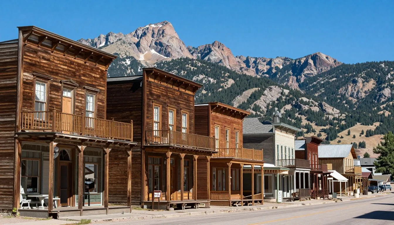
Historic Mining Sites
Abandoned mines dot the mountainsides throughout the Sawatch Range. These remnants from the late 1800s and early 1900s provide glimpses into Colorado’s mining heritage. Most sites remain dangerous and should only be viewed from a distance.
The town of Vicksburg, located south of Winfield, preserves several historic structures. This ghost town sits at 3,048 meters (10,000 feet) elevation along Clear Creek.
Location of Sawatch Plateau in central Colorado
Museums, Cultural Spots & Festivals
Cultural attractions in the Sawatch Plateau region focus on mining history and mountain heritage.
National Mining Hall of Fame and Museum
Located in Leadville, this museum showcases Colorado’s mining legacy. Exhibits include minerals, mining equipment, and stories of prospectors who shaped the region. The museum occupies a historic building in downtown Leadville.
Healy House Museum and Dexter Cabin
These restored historic homes in Leadville illustrate life during the mining boom years. The Healy House dates to 1878, while the Dexter Cabin represents a prosperous miner’s dwelling. Guided tours operate during summer months.
South Main Historic District
Buena Vista’s historic downtown area features preserved buildings from the late 1800s. Walking tours allow visitors to explore architectural details and learn about the town’s railroad history.
Nature & Outdoor Experiences

The Sawatch Plateau region provides endless opportunities for connecting with Colorado’s mountain environment.
Hiking Trails for All Abilities
Trail networks throughout the San Isabel National Forest accommodate hikers of varying experience levels. Short nature walks near campgrounds require minimal effort, while challenging summit routes test endurance and navigation skills.
The Colorado Trail passes through the heart of the Sawatch Range. This long-distance path stretches 788 kilometers (489 miles) from Denver to Durango. Day hikers can access numerous trailheads along the route for shorter excursions.
Arkansas River Activities
The Arkansas River flows through the valley between the Sawatch Range and the Mosquito Range. This waterway provides excellent fishing opportunities for rainbow, brown, and cutthroat trout.
Rafting and kayaking attract enthusiasts to various sections of the Arkansas River. Water levels peak during spring runoff in May and June. Commercial outfitters in Buena Vista offer guided trips and equipment rentals.
Wildlife Viewing
The Sawatch Range supports diverse wildlife populations. Elk herds roam throughout the area, particularly in high meadows during summer months. Bighorn sheep inhabit rocky ridges at higher elevations.
Black bears live throughout the forested slopes. Proper food storage becomes essential when camping to avoid attracting these animals. Mountain lions also inhabit the region but rarely show themselves to humans.
Wildflower Meadows
Alpine wildflowers transform mountain meadows into colorful displays during July and August. Columbines, Indian paintbrush, and alpine sunflowers bloom across hillsides. The short growing season at high elevations concentrates flowering into a brief period.
Fall Foliage Viewing
Aspen trees create stunning autumn displays throughout the Sawatch Range. Gold and orange leaves contrast with evergreen forests and gray mountain peaks. Late September and early October typically offer peak color viewing.
Cottonwood Pass Road and the road to Tincup provide exceptional foliage viewing opportunities. These routes wind through extensive aspen groves at mid-elevations.

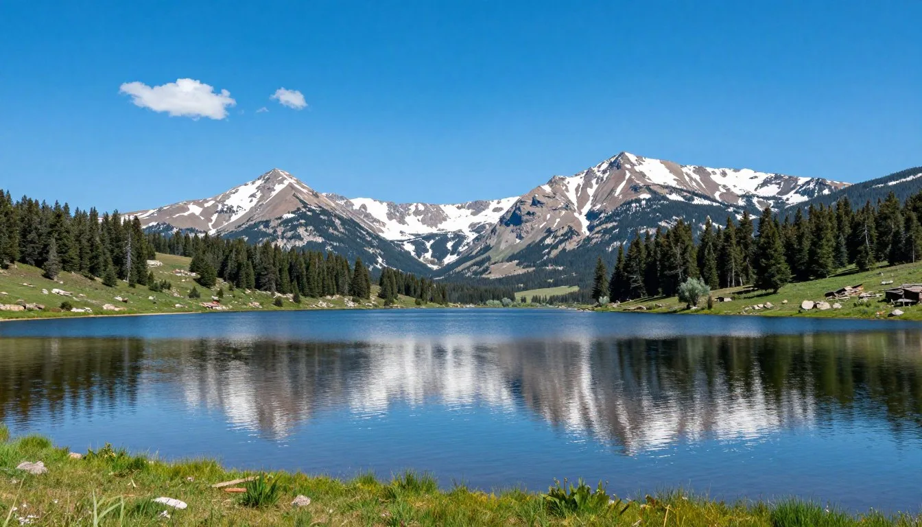
Mountain Lakes
Twin Lakes sits below Mount Elbert at 2,798 meters (9,180 feet) elevation. This scenic reservoir covers approximately 1,093 hectares (2,700 acres). The lake provides opportunities for fishing, kayaking, and camping along its shores.
Countless small alpine lakes dot the high country throughout the Sawatch Range. These remote waters require hiking to access but reward visitors with pristine mountain settings.
Travel With Children

Families discover numerous child-friendly activities throughout the Sawatch Plateau area. Careful planning ensures safe and enjoyable experiences for younger visitors.
Altitude Considerations
Children may experience altitude sickness above 2,438 meters (8,000 feet). Symptoms include headaches, nausea, and fatigue. Allow time for acclimatization before attempting strenuous activities. Stay hydrated and avoid rapid elevation gains.
Easy Family Hikes
Several trails near Buena Vista offer gentle terrain suitable for children. The Arkansas River Trail provides paved walking paths along the riverbank. Cottonwood Lake Trail features minimal elevation gain with beautiful mountain views.
Short nature walks near developed campgrounds introduce children to mountain environments without requiring long distances. These paths typically stay below 3 kilometers (2 miles) round trip.
River Activities for Families
Calm sections of the Arkansas River allow for safe wading and playing in summer months. Water remains cold year-round, typically 7°C to 13°C (45°F to 55°F). Supervise children closely near any moving water.
Some rafting outfitters offer family-friendly float trips on gentler river sections. These excursions provide adventure without extreme rapids.
Educational Opportunities
The National Mining Hall of Fame in Leadville offers exhibits that engage children’s curiosity about Colorado history. Interactive displays explain mining techniques and mineral formation.
Junior Ranger programs operate at various National Forest visitor centers during summer months. Children complete activity booklets to earn badges and certificates.
Money Saving Tips
Visiting the Sawatch Plateau region on a budget requires strategic planning. Several approaches help reduce expenses without sacrificing experience quality.
Free Recreation Areas
National Forest lands surrounding the Sawatch Range permit free access for hiking, viewing scenery, and dispersed camping. These public lands cover vast areas without entrance fees.
Many trailheads require no parking fees. However, some heavily used areas charge daily parking rates or require annual passes. Check specific locations before visiting.
Camping Versus Hotels
Campground fees range from $15 to $30 per night, significantly less than hotel rooms. Dispersed camping in National Forest areas costs nothing but requires more self-sufficiency.
Check 30,000+ Local Sightseeing Tours Worldwide
✓ Numerous languages and currencies are available
Campgrounds provide basic amenities adequate for comfortable stays. Cooking meals at campsites saves money compared to restaurant dining.
Visiting During Shoulder Seasons
Lodging prices drop during May, June, and September compared to peak summer months. Fewer crowds also enhance the experience at popular destinations.
Packing Your Own Food
Grocery stores in valley towns offer better prices than convenience stores in remote areas. Stock up on provisions before heading into the mountains. Bringing food from home saves even more money.
Free Entertainment
Natural attractions provide entertainment without admission charges. Scenic drives, wildlife viewing, and exploring ghost towns cost nothing beyond fuel expenses.
Safety, Etiquette & Local Customs
Mountain environments present unique hazards requiring awareness and preparation. Understanding local expectations helps visitors travel responsibly.
Altitude Safety
Acute mountain sickness affects many visitors above 2,438 meters (8,000 feet). Symptoms include headaches, dizziness, and shortness of breath. Ascend gradually and stay hydrated. Descend immediately if symptoms worsen.
High elevation intensifies ultraviolet radiation. Apply sunscreen frequently and wear protective clothing. Sunburns occur quickly at altitude even on cloudy days.
Weather Hazards
Lightning poses serious danger during afternoon thunderstorms. Leave exposed ridges and summits before storms develop. Avoid tall trees and open areas during electrical activity.
Hypothermia can occur even during summer months if visitors get wet and exposed to wind. Pack warm layers and rain protection for any mountain excursion.
Wildlife Safety
Black bears inhabit forested areas throughout the Sawatch Range. Store food in bear-resistant containers or hang it from trees when camping. Never approach or feed wildlife.
Mountain lions rarely attack humans but inhabit the region. Hike in groups and supervise children closely. Make noise while hiking to avoid surprising animals.
Leave No Trace Principles
Pack out all trash and waste materials. Bury human waste at least 15 centimeters (6 inches) deep and 61 meters (200 feet) from water sources. Use established campsites when available to minimize environmental impact.
Stay on designated trails to prevent erosion and vegetation damage. Shortcutting switchbacks accelerates trail degradation.
Local Customs and Courtesy
Mountain communities value respect for nature and neighbors. Keep noise levels reasonable, especially in campgrounds. Respect private property boundaries marked by fencing or signage.
Uphill hikers traditionally have right-of-way on narrow trails. Step aside to allow faster hikers to pass. Greet fellow trail users with friendly acknowledgment.
Fire Restrictions
Fire danger escalates during dry summer months. Check current restrictions before building campfires. Use established fire rings when fires are permitted. Extinguish fires completely before leaving camp or sleeping.
Stage 2 fire restrictions prohibit all open flames including camp stoves in some cases. Verify regulations with National Forest offices before your visit.
Visitor Comments About Sawatch Plateau Colorado
“The Sawatch Range exceeded all expectations. Mount Elbert was challenging but manageable for our group. We camped at Twin Lakes and enjoyed perfect weather throughout our visit. The Arkansas River Valley towns provided great food and friendly locals.”
“Incredible mountain scenery everywhere you look. We spent a week exploring different areas and barely scratched the surface. The wildflowers in July were spectacular. Our family appreciated the variety of hiking trails for different skill levels.”
“Coming from a flat country, these mountains took my breath away literally and figuratively. The altitude affected me more than expected, but we adjusted after a couple days. Buena Vista made an excellent base for day trips. Worth the long journey from Europe.”
Additional Nearby Destinations

The central Colorado region surrounding the Sawatch Plateau offers numerous additional destinations worth exploring.
Aspen and the Roaring Fork Valley
Aspen lies approximately 64 kilometers (40 miles) northwest of the central Sawatch Range. This famous resort town provides upscale dining, shopping, and cultural attractions. Independence Pass connects Aspen with Twin Lakes during summer months.
The Maroon Bells, located near Aspen, rank among Colorado’s most photographed peaks. These distinctive mountains rise above Maroon Lake in a spectacular setting.
Crested Butte and Taylor Park
Crossing Cottonwood Pass leads to Taylor Park and eventually Crested Butte. This mountain town offers summer hiking and world-class mountain biking trails. The area features extensive wildflower meadows during July and August.
Salida and the Arkansas River
South of Buena Vista, Salida sits along the Arkansas River. This artistic community features galleries, breweries, and river activities. The town serves as another access point for exploring the southern Sawatch Range.
San Luis Valley
The San Luis Valley spreads south of the Sawatch Range. This high-altitude basin contains unique attractions including Great Sand Dunes National Park. The valley offers completely different scenery from the mountain environment.
Colorado Springs and Pikes Peak
Colorado Springs lies approximately 153 kilometers (95 miles) southeast. Pikes Peak, Garden of the Gods, and numerous other attractions make this city worth visiting. The area provides a different perspective on Colorado’s Rocky Mountains.
Practical Travel Tips
Final considerations help ensure a smooth and enjoyable visit to the Sawatch Plateau region.
Essential Gear Checklist
- Layered clothing including warm jacket and rain protection
- Sturdy hiking boots with ankle support
- Sunscreen, sunglasses, and sun hat
- Plenty of water bottles or hydration system
- Detailed topographic maps and compass or GPS device
- First aid kit with altitude sickness medication
- Headlamp or flashlight with extra batteries
- Emergency whistle and fire starter
Physical Preparation
High-altitude hiking demands good cardiovascular fitness. Begin training several weeks before your trip if you live at low elevation. Walking, running, or stair climbing builds necessary endurance.
Arrive at least one full day before attempting strenuous activities. This acclimatization period allows your body to adjust to reduced oxygen levels.
Communication and Connectivity
Cell phone coverage remains unreliable throughout much of the Sawatch Range. Download offline maps and share your itinerary with someone before heading into remote areas. Satellite communication devices provide emergency contact capability in the backcountry.
Permits and Regulations
Most day hiking requires no permits in the San Isabel National Forest. Overnight camping may require registration at some trailheads. Wilderness areas prohibit mechanized transportation including bicycles.
Check current regulations regarding campfires, camping locations, and group size limits before your visit. Rules change based on current conditions and fire danger levels.
Photography Tips
Morning and evening light create optimal conditions for mountain photography. Golden hour illuminates peaks with warm tones. Afternoon thunderstorms often produce dramatic cloud formations.
Bring extra batteries as cold temperatures drain power quickly. Protect camera equipment from moisture during sudden weather changes.
Responsible Travel
Support local businesses in mountain communities. Small towns depend on tourism revenue for economic survival. Purchase supplies, eat at local restaurants, and stay in locally-owned accommodations when possible.
Respect trail closures and seasonal restrictions. These measures protect wildlife, allow vegetation recovery, or maintain public safety during hazardous conditions.
Health Precautions
Drink more water than normal at high elevation. Dehydration occurs quickly in the dry mountain air. Avoid alcohol consumption during initial acclimatization as it worsens altitude effects.
Monitor yourself and companions for signs of altitude sickness, hypothermia, or heat exhaustion. Recognize symptoms early and respond appropriately before conditions become serious.
Your Sawatch Adventure Awaits
The Sawatch Plateau Colorado region stands ready to deliver unforgettable mountain experiences. Towering peaks pierce the sky while pristine valleys offer peaceful retreats. Each season transforms the landscape, creating new opportunities for exploration and discovery.
Whether you climb to Colorado’s highest summits or simply breathe the crisp mountain air, the Sawatch Range will leave lasting impressions. These mountains have witnessed millions of years of geological change. Now they invite you to create your own memories among their ancient peaks.
Start planning your journey today. The trails, rivers, and ridges await your footsteps. Adventure calls from every direction in this magnificent corner of the Rocky Mountains.