Hotels by Trip.com
Flights by Trip.com
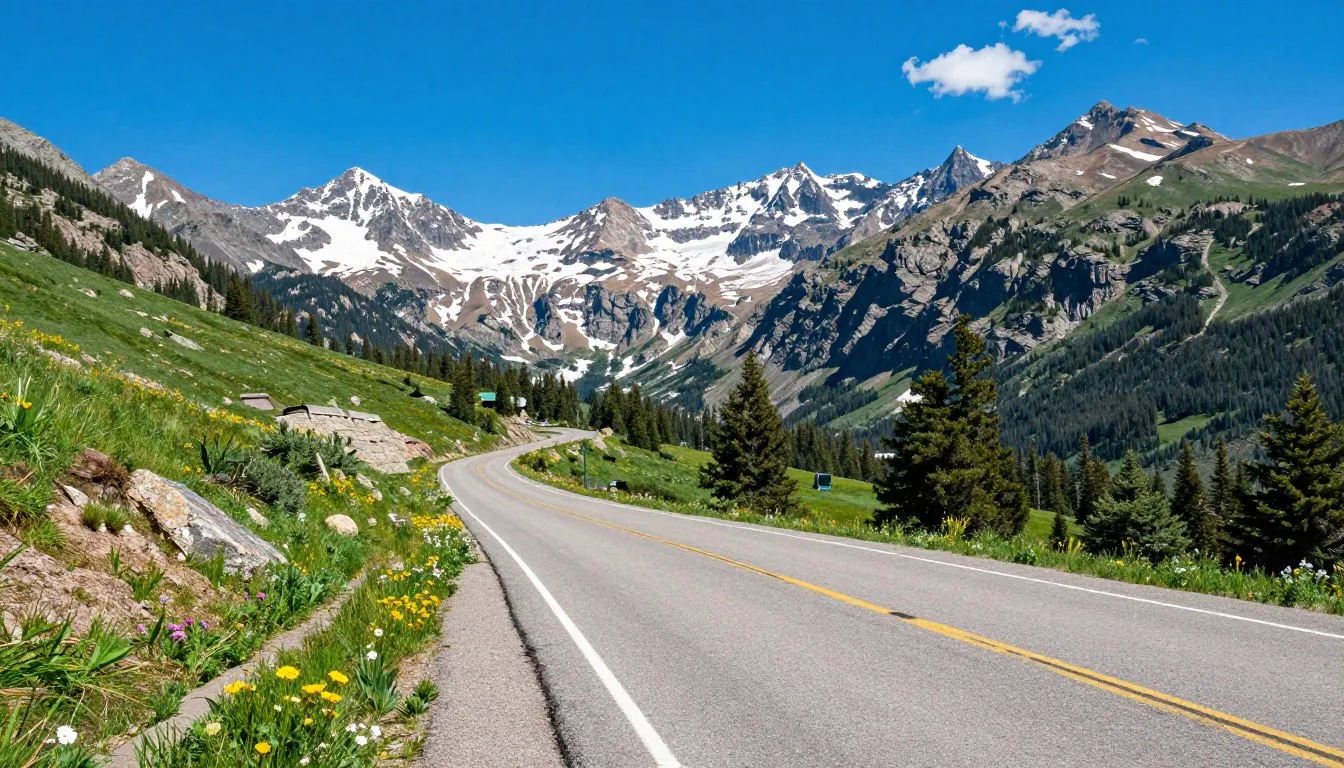
Every year, more than 15,000 adventurous travelers navigate Taylor Pass Road, making it one of Colorado’s most sought-after high-altitude backcountry routes. This historic mountain pass sits at 3,658 meters (12,000 feet) elevation, connecting Aspen with Taylor Park through some of the most dramatic alpine scenery in the Rocky Mountains. The road earned its name from Jim Taylor, a prospector who discovered silver in the area during the 1880s mining boom.
Winding through pristine wilderness, Taylor Pass Road offers an unforgettable journey. Massive boulders line the trail. Wildflower meadows burst with color in summer. Creek crossings test your vehicle’s capabilities. The views reward every challenging moment.
This comprehensive guide reveals everything you need to know. From planning your journey to discovering hidden gems, you’ll find practical advice. Safety tips help you navigate challenging terrain. Local insights ensure you experience the best this mountain pass offers.
Getting There & Planning Your Journey

Reaching Taylor Pass Road requires careful planning and preparation. The nearest major airport is Aspen-Pitkin County Airport (ASE), located just 6.4 kilometers (4 miles) from downtown Aspen. This regional airport offers seasonal flights from major cities including Denver, Los Angeles, and Chicago. For more flight options, Denver International Airport (DEN) sits 354 kilometers (220 miles) northeast and provides year-round service from hundreds of destinations worldwide.
From Aspen, the trailhead begins on Castle Creek Road. Drive south from town following Highway 82 for about 8 kilometers (5 miles). Turn right onto Castle Creek Road and continue for approximately 18 kilometers (11 miles) until you reach the marked trailhead. The route from Aspen to Taylor Pass covers roughly 32 kilometers (20 miles) of increasingly challenging terrain.
Taylor Park approach offers an alternative route. This eastern access point starts near the small community of Taylor Park Reservoir. From Gunnison, drive north on Highway 135 for about 45 kilometers (28 miles), then follow County Road 742 west toward the reservoir. This route provides easier initial access but still requires high clearance vehicles for the final ascent.
Ground Transportation Services: Several shuttle companies operate between Denver International Airport and Aspen. Colorado Mountain Express and Fresh Tracks Transportation offer door-to-door service with advance reservations recommended during peak seasons.
Vehicle rental proves essential for Taylor Pass Road exploration. Standard rental cars cannot handle this route. You need a high clearance four-wheel-drive vehicle with good tires and adequate ground clearance. Several Aspen rental agencies specialize in off-road capable vehicles including Jeeps and trucks suitable for mountain passes.
Best Time to Visit & Weather Tips

Taylor Pass Road operates on a limited seasonal schedule. The pass typically opens in mid-July and closes by mid-September. Snow blocks the route for nine months each year, making summer the only viable time for passage.
July through August represents peak season. Weather remains most stable during these months. Daytime temperatures range from 15°C to 24°C (60°F to 75°F) at lower elevations. The summit stays cooler, often between 7°C and 15°C (45°F and 60°F). Afternoon thunderstorms develop frequently, creating dangerous conditions on exposed ridges.
Early September offers excellent weather before the pass closes. Crowds thin considerably after Labor Day. Aspen trees begin their spectacular golden transformation. However, early snowstorms can arrive without warning, potentially trapping unprepared travelers.
Avoid late afternoon crossings during summer months. Thunderstorms typically build between 2 PM and 5 PM. Lightning poses serious risks at high elevation. Flash flooding can make creek crossings impassable. Morning departures provide the safest weather windows.
Best Months
Optimal conditions occur during specific periods throughout the brief summer season.
- Late July – stable weather, all snow melted
- Early August – warmest temperatures, driest conditions
- Early September – fewer crowds, fall colors emerging
- Weekday visits – less traffic, better trail conditions
Months to Avoid
Certain periods present significant challenges and safety concerns for travelers.
- October through June – pass completely closed by snow
- Early July – lingering snowfields, unstable creek crossings
- Late September – early winter storms possible
- Weekend peak times – heavy traffic creates bottlenecks
Notable Annual Festivals
While Taylor Pass Road itself hosts no festivals, nearby Aspen offers numerous annual events. The Aspen Music Festival runs from late June through August, bringing world-class performances to the mountain town. Food & Wine Classic occurs each June, attracting culinary enthusiasts from across the country. The Aspen Film Festival lights up screens each September, coinciding with prime fall foliage viewing.
For festival information and scheduling, contact the Aspen Chamber Resort Association at +1 (970) 925-1940. They provide current event calendars and can help coordinate your visit around specific festivals.
Getting Around Locally

Taylor Pass Road demands specialized transportation. No public transit services operate on this backcountry route. Your vehicle choice determines your success and safety on the trail.
High clearance four-wheel-drive vehicles represent the minimum requirement. Stock SUVs with adequate ground clearance can complete the journey during good conditions. Lifted trucks and Jeeps handle obstacles more confidently. Rock sliders protect your vehicle’s undercarriage from damage.
Tire selection matters significantly. All-terrain tires provide better grip on loose rocks and dirt. Maintain proper tire pressure for off-road conditions, typically reducing pressure by 2-3 PSI improves traction. Carry a full-size spare tire and know how to change it on uneven terrain.
Several outfitters in Aspen rent properly equipped vehicles. Blazing Adventures offers Jeep rentals specifically configured for mountain passes. They provide basic trail maps and safety briefings with each rental. Advance reservations during summer months prove essential as inventory sells out quickly.
Local Expert Tip: Air down your tires slightly before starting the steep rocky sections. The increased tire footprint provides better traction on loose surfaces and reduces the likelihood of punctures from sharp rocks.
Fuel availability becomes critical for remote exploration. Aspen offers numerous gas stations, but Taylor Park services remain limited. Fill your tank completely before departure. The round trip from Aspen through Taylor Pass to Taylor Park and back covers approximately 145 kilometers (90 miles) of challenging terrain that consumes more fuel than highway driving.
GPS navigation works inconsistently in the mountains. Cellular service disappears completely on most of the route. Download offline maps before your journey. Paper topographic maps provide essential backup navigation. The USGS 7.5-minute quadrangle maps for Pearl Pass and Taylor Park show terrain details GPS units miss.
Where to Stay

Accommodation options near Taylor Pass Road range from luxury resorts to primitive campsites. Most visitors base themselves in Aspen or establish camps closer to the trailhead.
Aspen hotels provide full-service comfort with easy trail access. The Limelight Hotel offers mountain-view rooms, complimentary breakfast, and secure parking for off-road vehicles. St. Regis Aspen Resort delivers five-star luxury with a spa, multiple restaurants, and concierge services to arrange guided excursions. Budget-conscious travelers appreciate the Aspen Mountain Lodge, providing clean comfortable rooms at moderate prices.
For lodging reservations in Aspen, contact the Aspen Central Reservations at +1 (970) 925-1940. They represent multiple properties and can match your needs with available inventory.
Taylor Park offers rustic accommodations for those preferring the eastern approach. Taylor Park Trading Post operates a small lodge with basic rooms and a general store. Several private cabins provide rental options through local property management companies. These locations place you closer to the pass but sacrifice amenities available in Aspen.
Camping Options
Dispersed camping along Castle Creek Road provides free alternatives near the western trailhead. Multiple established sites exist in the White River National Forest. These primitive locations offer no services but allow early morning starts. Follow Leave No Trace principles and pack out all waste.
Taylor Park Reservoir features developed campgrounds with more facilities. Lakeview Campground and Rivers End Campground offer vault toilets, picnic tables, and lake access. Sites fill quickly on summer weekends. Reservations through Recreation.gov help secure spots during peak season.
Camping Regulations: A free wilderness permit is required for overnight camping in many areas. Contact the Aspen Ranger District at +1 (970) 925-3445 for current regulations, fire restrictions, and permit requirements before your trip.
Backcountry camping along Taylor Pass Road itself remains permitted in designated areas. The treeline disappears above 3,353 meters (11,000 feet), exposing campers to severe weather. Wind, lightning, and sudden temperature drops create dangerous conditions. Only experienced wilderness campers should attempt overnight stays near the summit.
Dining & Local Cuisine

Aspen’s dining scene offers everything from casual cafes to world-class restaurants. After challenging days on Taylor Pass Road, numerous options satisfy hungry adventurers.
White House Tavern serves hearty American comfort food perfect for refueling. Their burgers, steaks, and craft beer selection attract locals and visitors alike. Casual atmosphere and generous portions make it popular with outdoor enthusiasts.
Matsuhisa brings Japanese-Peruvian fusion cuisine to the mountains. Celebrity chef Nobu Matsuhisa created this elegant restaurant featuring fresh sushi, innovative cooked dishes, and an extensive sake list. Reservations prove essential during peak season.
Cache Cache prepares French-American cuisine in an intimate setting. Seasonal menus showcase local ingredients including Colorado lamb, Rocky Mountain trout, and foraged mushrooms. The wine list features exceptional selections from around the world.
Quick Meals and Trail Provisions
City Market provides full grocery services for those preparing their own meals or packing trail lunches. The deli counter makes fresh sandwiches perfect for mountain excursions. Stock up on water, snacks, and emergency food supplies before heading to the pass.
Explore Booksellers & Bistro combines a bookshop with a casual cafe. Grab excellent coffee, pastries, and light meals while browsing regional guidebooks and maps. Their staff knows local trails and can provide current condition updates.
Taylor Park Trading Post offers limited dining options on the eastern side. The small general store sells basic groceries, snacks, and camping supplies. Hot coffee and simple breakfast items attract early morning travelers preparing for the pass crossing.
Trail Dining Tip: Pack more food and water than you think you’ll need. The high altitude, physical exertion, and unpredictable delays mean you’ll consume significantly more calories than normal. Include high-energy snacks like nuts, dried fruit, and energy bars.
Attractions, Sightseeing & Activities

Taylor Pass Road itself serves as the main attraction. The 32-kilometer (20-mile) route from Aspen to the summit delivers non-stop scenery and adventure. Each section presents unique challenges and rewards.
The initial stretch follows Castle Creek through dense aspen and conifer forests. Well-maintained dirt road allows comfortable progress. Impressive views of surrounding peaks appear through breaks in the trees. This section provides a deceptive introduction to the increasingly difficult terrain ahead.
Above treeline, the landscape transforms completely. Alpine tundra stretches across rolling hillsides. Wildflowers create spectacular displays during July and August. Indian paintbrush, alpine sunflowers, and columbine paint the meadows in brilliant colors. The fragile ecosystem requires careful foot placement to avoid damaging delicate plants.
Taylor Lake
A detour to Taylor Lake adds 3.2 kilometers (2 miles) to your journey. This pristine alpine lake sits at 3,505 meters (11,500 feet) in a dramatic cirque. Steep rocky walls rise on three sides. The crystal-clear water reflects surrounding peaks on calm days. Experienced mountain bikers tackle the trail to the lake, though most visitors hike the final section.
Fishing in Taylor Lake produces brook trout and cutthroat trout. Colorado fishing regulations apply. A valid state fishing license is required for anyone age 16 and older. The cold water and high altitude limit fish size, but the spectacular setting makes every catch memorable.

Rock Crawling Challenges
Several notorious rock obstacles test vehicle capabilities and driver skill. The boulder field between mile markers 8 and 9 forces careful line selection. Massive rocks create wheel-grabbing gaps. Spotters help drivers navigate the safest routes through these sections.
Experienced off-road drivers relish these technical challenges. Beginners should expect slow progress and possibly some vehicle contact with rocks. Rock sliders and skid plates prevent serious damage to most properly equipped vehicles.
Creek Crossings
Multiple creek crossings add excitement and risk to the journey. Water depth varies dramatically based on recent weather, snowmelt, and time of day. Early morning typically offers the lowest water levels as overnight freezing temperatures reduce meltwater flow.
The main creek crossing near mile 12 requires careful assessment. Water can reach 45 centimeters (18 inches) deep during peak runoff. Walking across first to check depth and bottom conditions prevents costly mistakes. Maintain steady momentum through flowing water but avoid excessive speed that creates waves.
Important Safety Note: Never attempt creek crossings during or immediately after heavy rainfall. Flash flooding can turn gentle streams into raging torrents within minutes. If water appears too high or fast, turn around. No destination is worth risking your life or vehicle.
Museums, Cultural Spots & Festivals

Taylor Pass Road winds through Colorado mining history. Abandoned cabins and mining claims dot the landscape, silent witnesses to the 1880s silver boom that drove settlement in these remote mountains.
Several deteriorating structures survive along the route. These fragile historical artifacts deserve respect and preservation. View them from a distance. Entering unstable buildings risks injury and accelerates their collapse. Photograph the sites to capture their atmosphere without causing damage.
Aspen Historical Society operates the Wheeler/Stallard Museum in downtown Aspen. This Victorian home showcases life during the silver mining era. Exhibits detail the boom-and-bust cycles that shaped the region. Guided tours provide context for the ruins you’ll encounter on Taylor Pass Road. The museum opens Wednesday through Saturday from 1 PM to 5 PM.
Aspen Art Museum
Contemporary art finds a home at the Aspen Art Museum. The striking modern building contrasts with historic Victorian architecture downtown. Free admission makes it accessible to all visitors. Rotating exhibitions feature works by established and emerging artists. The rooftop sculpture garden offers mountain views alongside outdoor installations.
Cultural Events in Aspen
Aspen’s summer cultural calendar rivals major cities. The Aspen Music Festival and School presents classical music performances from late June through August. Student recitals, chamber music, and full orchestra concerts fill venues across town. Many events offer free admission, making world-class music accessible during your mountain adventures.
Theatre Aspen produces professional summer theater at multiple venues. Broadway musicals, contemporary plays, and original works entertain audiences throughout the season. The Hyman Avenue Mall hosts free performances on summer evenings, creating a festive atmosphere in the pedestrian zone.
Nature & Outdoor Experiences

Beyond driving the pass itself, numerous outdoor activities surround Taylor Pass Road. The high-altitude environment creates unique recreational opportunities for properly prepared visitors.
Mountain Biking
Experienced mountain bikers tackle Taylor Pass as an epic ride. The route covers approximately 48 kilometers (30 miles) from Aspen to Taylor Park with over 1,067 meters (3,500 feet) of climbing. Technical rock sections, steep grades, and loose surfaces demand advanced skills and excellent fitness.
Most riders arrange vehicle shuttles to avoid the grueling climb. Drop vehicles at Taylor Park, drive back to Aspen, then ride the predominantly downhill route east. This approach allows more time enjoying the descent and reduces exhaustion-related accidents.
Bike shops in Aspen rent full-suspension mountain bikes suitable for rough terrain. The Hub of Aspen provides quality rental fleet and can recommend current trail conditions. Reserve bikes several days in advance during peak summer season.
Hiking Opportunities
Numerous hiking trails branch from Taylor Pass Road. The pass summit offers access to multiple peaks exceeding 3,962 meters (13,000 feet). Summit attempts require early starts, proper acclimatization, and awareness of afternoon thunderstorm patterns.
Star Peak rises to 4,161 meters (13,655 feet) via a challenging scramble from the pass. The route follows a steep ridge with loose rock and significant exposure. Only experienced peak-baggers should attempt this climb. Allow 6-8 hours round trip from the pass.

Easier walks explore alpine meadows near the pass. Short hikes of 1-2 kilometers let you stretch your legs and capture photographs without committing to major ascents. Stay on established trails to protect fragile tundra vegetation that takes decades to recover from footprints.
Wildlife Viewing
The Taylor Pass area supports diverse wildlife populations. Elk frequent the lower valleys, especially during early morning and evening hours. Bighorn sheep inhabit rocky areas above treeline. Marmots and pikas thrive in boulder fields, their whistles warning of approaching visitors.
Black bears roam throughout the region. Store all food in bear-proof containers or locked vehicles. Never approach or feed wildlife. Maintain at least 50 meters (150 feet) distance from large animals. Carry bear spray and know how to use it properly.
Bird enthusiasts spot numerous species including ptarmigan, rosy-finches, and birds of prey. Golden eagles soar above ridgelines hunting for marmots and ground squirrels. Bring binoculars to observe wildlife without disturbing their natural behaviors.
Travel With Children

Taylor Pass Road presents challenges for families with young children. The rough terrain, high altitude, and remote location require careful consideration before bringing kids on this adventure.
Children under age 10 often struggle with the long drive over bumpy roads. Motion sickness becomes common on winding mountain routes with constant vehicle movement. Pack appropriate medications, plastic bags, and plan frequent stops to let kids stretch their legs.
Altitude sickness affects children as readily as adults. The pass summit sits at 3,658 meters (12,000 feet), where oxygen levels drop significantly. Watch for symptoms including headache, nausea, fatigue, and unusual irritability. Descend immediately if serious symptoms develop.
Kid-Friendly Activities
Lower sections of Castle Creek Road offer family-friendly exploration. Several pullouts provide safe places to exit vehicles and explore meadows. Short walks let children discover wildflowers, throw rocks in the creek, and experience mountain environments without dangerous exposure.
Rock hunting entertains kids during stops. The area contains interesting geological specimens including quartz crystals, mica schist, and various granites. Teach children to observe and photograph specimens rather than filling pockets with heavy rocks.
Wildlife spotting creates exciting moments for young observers. Marmots sunning on rocks, chipmunks scurrying through vegetation, and overhead bird flights capture children’s attention. Bring binoculars sized for small hands to enhance their viewing experience.
Family Safety Tip: Children should remain inside vehicles during challenging rock obstacles and creek crossings. The temptation to “help” by spotting or wading can lead to injuries. Save the exploring for safe pullouts away from moving vehicles and deep water.
Aspen offers numerous child-friendly alternatives to the difficult pass crossing. The Maroon Bells viewing area provides spectacular mountain scenery via paved road. Grottos Trail presents an easy 1.6-kilometer (1-mile) hike through ice caves. These options let families experience Colorado’s beauty without the risks of extreme four-wheel-drive routes.
Money Saving Tips

Exploring Taylor Pass Road on a budget requires planning and smart choices. Aspen’s reputation for luxury pricing makes cost management essential for budget-conscious travelers.
Vehicle rental represents your largest expense. Booking far in advance secures better rates on four-wheel-drive vehicles. Consider renting from locations outside Aspen where daily rates run 20-30% lower. Glenwood Springs and Carbondale offer rental agencies with mountain-capable vehicles at reduced prices compared to resort-town rates.
Camping instead of hotels saves hundreds of dollars. Free dispersed camping along Castle Creek Road eliminates accommodation costs entirely. Developed campgrounds at Taylor Park charge only modest fees of $20-25 per night compared to Aspen hotel rates exceeding $300 nightly during peak season.
Food and Provisions
Grocery shopping in Aspen strains budgets with resort-town pricing. Stock up on supplies before reaching the mountains. Glenwood Springs grocery stores offer standard pricing on camping food, snacks, and beverages. A well-stocked cooler eliminates expensive restaurant meals.
Pack lunches for trail days rather than purchasing food in Aspen. Simple sandwiches, fruit, trail mix, and plenty of water cost a fraction of restaurant prices. Reusable water bottles refilled from safe sources save money and reduce plastic waste.
Many Aspen cultural events offer free admission. Aspen Music Festival presents numerous concerts without charge. The Aspen Art Museum never charges admission. Free walking tours of historic downtown run regularly during summer months. These quality experiences cost nothing but provide authentic local culture.
Strategic Timing
Visiting during shoulder season dramatically reduces costs. Early July before peak season or September after Labor Day offer significantly lower rates on lodging and rentals. Weather remains generally favorable while prices drop 30-50% from peak August levels.
Weekday travel saves money on campground fees and accommodates budget constraints better than weekend trips. Many facilities offer lower weekday rates or increased availability that eliminates premium pricing.
Budget Planning: A DIY Taylor Pass adventure costs approximately $200-400 for a long weekend including vehicle rental, camping fees, food, and fuel. This compares favorably to guided tour prices of $800-1,200 per person for similar experiences.
Safety & Local Customs

Taylor Pass Road demands respect for both natural hazards and local regulations. Understanding risks and proper protocols keeps you safe while preserving this special environment.
Weather changes rapidly at high altitude. Blue skies can transform into violent thunderstorms within an hour. Lightning poses extreme danger above treeline where you become the tallest object on exposed ridges. Monitor weather forecasts before departure and watch clouds throughout the day. Descend immediately when thunderstorms approach.
Creek crossings present drowning and vehicle damage risks. Water depth fluctuates throughout the day as snowmelt increases during warm afternoons. Always walk crossings first to assess depth, current speed, and bottom stability. If water reaches above your knees while walking, it’s too deep for safe vehicle passage.
Emergency Preparedness
Cell phone service does not exist on most of Taylor Pass Road. Satellite communication devices provide your only connection to emergency services. InReach or SPOT devices allow you to summon help when traditional phones fail. Rent or purchase one before attempting remote mountain routes.
Medical emergencies at high altitude require evacuation to lower elevations. Pitkin County Search and Rescue responds to emergencies but response times in remote areas can exceed several hours. Carry comprehensive first aid supplies and know how to treat altitude sickness, hypothermia, and traumatic injuries.
For emergency assistance, contact Pitkin County Sheriff’s Office at +1 (970) 920-4310. In true life-threatening emergencies, call 911. Dispatchers can coordinate rescue operations even when you cannot provide precise GPS coordinates.
Critical Safety Warning: Never attempt Taylor Pass Road alone. Mechanical breakdowns, injuries, or getting stuck leave solo travelers without help. Groups of at least two vehicles provide mutual assistance when problems occur. If you must travel solo, file detailed trip plans with someone reliable who will alert authorities if you don’t return on schedule.
Local Customs and Etiquette
Trail etiquette ensures everyone enjoys the backcountry safely. Vehicles traveling uphill have right-of-way on narrow sections. Downhill drivers must back up to wider areas when meeting oncoming traffic. This custom prevents vehicles from losing traction on steep climbs.
Dirt bikes and ATVs share some sections of Taylor Pass Road. These smaller vehicles move faster but have equal trail rights. Give them space to pass safely. Motorcyclists often carry less safety equipment than enclosed vehicle occupants, making defensive driving essential.
Leave No Trace principles apply throughout the route. Pack out all trash including biodegradable items like orange peels and apple cores. Stay on established roads to prevent vegetation damage. Never cut switchbacks or create new tracks across fragile alpine tundra.
Respect private property along lower sections of the road. Some land parcels remain privately owned despite the route’s public recreation status. Camping, parking, or hiking require landowner permission in these areas. Recognize and honor posted boundaries.
Visitor Comments About Taylor Pass Road

Travelers who have experienced Taylor Pass Road share their perspectives on this challenging mountain adventure.
“The views from Taylor Pass absolutely took my breath away. Every rocky obstacle and creek crossing felt worth the effort once we reached the summit. The wildflower displays in late July created the most beautiful landscape I’ve ever photographed. Our Jeep handled the trail well, though a few sections had me questioning our route choice. We camped near Taylor Park and watched an incredible sunset over the mountains. This adventure ranks among my top Colorado experiences.”
“Taylor Pass Road tested our vehicle and our nerves. The boulder fields required careful navigation and several attempts to find clean lines through the rocks. Creek crossings ran deeper than expected, making for some anxious moments. That said, the scenery justified the challenges. Alpine meadows stretched for miles in every direction. We spotted elk, marmots, and even a golden eagle hunting above the pass. I recommend this route only for experienced off-road drivers with properly equipped vehicles. It’s not a casual Sunday drive.”
“As a mountain biker, Taylor Pass presented the ultimate Colorado challenge. The climb from Aspen destroyed my legs, but gravity made the descent incredibly rewarding. Technical rock gardens tested my handling skills while the high altitude left me gasping on steep sections. I arranged a vehicle shuttle to avoid the brutal return climb. The effort delivered an unforgettable ride through pristine wilderness. Experienced mountain bikers will love this trail, though beginners should choose easier routes. Proper preparation and fitness make all the difference on this demanding adventure.”
Additional Nearby Destinations

Taylor Pass Road serves as gateway to numerous other Colorado destinations. Extend your mountain adventure by exploring nearby attractions and scenic routes.
Maroon Bells represent Colorado’s most photographed peaks. Located just 16 kilometers (10 miles) west of Aspen, these twin summits rise to 4,317 meters (14,163 feet). Maroon Lake reflects the peaks perfectly on calm mornings. A paved road provides easy access, though summer restrictions require shuttle buses during peak hours. The short hike around the lake suits all fitness levels.
Independence Pass climbs to 3,687 meters (12,095 feet) on Highway 82 between Aspen and Twin Lakes. This paved mountain pass remains open June through October, offering spectacular alpine scenery without four-wheel-drive requirements. The summit provides interpretive displays about the Continental Divide and local ecology. Multiple hiking trails access high-altitude wilderness areas.
Crested Butte
This historic mining town sits 48 kilometers (30 miles) south of Taylor Park. Known as “Colorado’s Last Great Ski Town,” Crested Butte maintains authentic character despite world-class skiing and mountain biking. The wildflower capital of Colorado explodes with color during July. Victorian-era buildings house galleries, restaurants, and boutiques along Elk Avenue.
Pearl Pass connects Aspen with Crested Butte via an even more challenging four-wheel-drive route. This 3,962-meter (13,000-foot) pass requires expert off-road skills and excellent vehicle preparation. Only attempt Pearl Pass after successfully completing Taylor Pass several times.
Gunnison National Forest
East of Taylor Pass, Gunnison National Forest encompasses over 688,000 hectares (1.7 million acres) of public land. Countless hiking trails, fishing streams, and camping areas spread across this vast wilderness. The forest provides unlimited exploration opportunities for outdoor enthusiasts seeking less-crowded alternatives to Aspen-area destinations.
Black Canyon of the Gunnison National Park lies 97 kilometers (60 miles) southeast of Taylor Park. Vertical rock walls plunge 823 meters (2,700 feet) to the Gunnison River below. The narrow canyon creates some of Colorado’s most dramatic scenery. Rim drives and hiking trails provide access to spectacular overlooks.
Practical Travel Tips

Successful Taylor Pass Road adventures require thorough preparation and attention to detail. These practical tips help ensure safe, enjoyable experiences on this challenging route.
Essential Equipment Checklist
- Full-size spare tire properly inflated and mounted
- Tire repair kit with plugs and CO2 inflator
- Recovery straps rated for your vehicle weight
- Shovel for digging out stuck vehicles
- First aid kit with altitude sickness medications
- Emergency shelter and warm clothing layers
- Fire starter and waterproof matches
- Paper maps and compass for backup navigation
Water requirements exceed normal consumption at high altitude. Bring at least 4 liters per person for day trips. Dehydration accelerates altitude sickness and impairs judgment on technical terrain. Water bottles with measurement markings help track consumption throughout the day.
Sun protection becomes critical above treeline. UV radiation increases approximately 10% for every 305 meters (1,000 feet) of elevation gain. Bring high-SPF sunscreen, protective clothing, sunglasses, and wide-brimmed hats. Reapply sunscreen every two hours regardless of cloud cover.
Vehicle Preparation
Complete mechanical inspection before attempting mountain passes prevents breakdowns in remote locations. Check fluid levels including oil, coolant, brake fluid, and transmission fluid. Inspect belts and hoses for cracks or wear. Test your four-wheel-drive system in a safe area before committing to difficult trails.
Brake systems work harder on mountain descents. Ensure brake pads have adequate material remaining. Worn brakes on steep downhills lead to fade and potential loss of control. Use engine braking in low gears rather than riding brakes continuously on long descents.
Skid plates protect expensive components from rock damage. Oil pans, transmission cases, and transfer cases all sit vulnerable beneath your vehicle. Aftermarket skid plates cost a fraction of repair bills from punctured components. Many rental companies offer vehicles already equipped with protective armor.
Visitor Information Resources: Contact Aspen Visitor Center at +1 (970) 925-1940 for current trail conditions, weather forecasts, and general trip planning assistance. Staff can recommend outfitters, provide maps, and connect you with local expertise.
Photography Tips
Taylor Pass Road offers endless photographic opportunities. Morning light between 6 AM and 9 AM provides warm tones and dramatic shadows. Afternoon thunderstorm clouds create dynamic skies but signal time to descend. Sunset from high elevations produces stunning alpenglow on surrounding peaks.
Protect camera equipment from dust and vibration during rough sections. Padded camera bags prevent damage from constant vehicle movement. Bring extra batteries as cold mountain air depletes battery life faster than at sea level. Memory cards with ample storage capacity ensure you never miss shots waiting for space.
Polarizing filters reduce glare from rocks and enhance sky colors. Wide-angle lenses capture expansive mountain vistas while telephoto lenses isolate distant peaks and wildlife. Tripods stabilize cameras for sharp images in low light conditions during dawn and dusk photography sessions.
Your Mountain Adventure Awaits
Taylor Pass Road beckons adventurous spirits to experience Colorado’s high country in its most pristine form. Every challenging rock obstacle, every creek crossing, every breathtaking vista contributes to an unforgettable journey through the heart of the Rocky Mountains. Whether you navigate the route behind the wheel, conquer it on mountain bike, or hike the surrounding peaks, Taylor Pass delivers authentic wilderness experiences increasingly rare in our developed world.
Prepare thoroughly, respect the environment, and embrace the challenges this remarkable route presents. The memories you create among these magnificent mountains will inspire future adventures and deepen your connection to Colorado’s wild places. Start planning your Taylor Pass Road expedition today, and discover why thousands of travelers consider this one of America’s most rewarding backcountry routes.