Hotels by Trip.com
Flights by Trip.com
Did you know that Cedar Mountain Wilderness reaches an elevation gain of over 762 meters (2,500 feet) from trailhead to summit, yet fewer than 500 people complete this moderate hike annually? This hidden gem in Utah’s West Desert remains one of the state’s most pristine and uncrowded wilderness areas.
The cedar mountain wilderness region offers adventurers a rare glimpse into untouched Utah backcountry. Located far from tourist crowds, this remote destination challenges visitors with its rugged terrain and rewards them with spectacular summit views.
Whether you’re seeking a challenging ridge hike, peaceful solitude on animal trails, or breathtaking views from the top of a prominent peak, Cedar Mountain delivers an authentic wilderness experience. This comprehensive guide covers everything you need to plan your adventure to this remarkable destination.
Getting There & Planning Your Journey

Reaching Cedar Mountain Wilderness requires careful route planning. The journey takes you through Utah’s remote West Desert, where dirt roads and limited services define the landscape.
Closest Airports
Salt Lake City International Airport (SLC) serves as the primary gateway, located approximately 201 kilometers (125 miles) northeast of the wilderness area. This major hub offers rental cars and travel services.
Provo Municipal Airport provides a smaller alternative, situated about 169 kilometers (105 miles) from Cedar Mountain. Direct flights are limited, but the drive offers scenic views of Utah Lake.
Road Access and Route Conditions
The main access route follows Highway 36 south from Tooele. After passing Vernon, you’ll turn onto dirt roads leading toward the trailhead. High-clearance vehicles are strongly recommended for the final approach.
Spring conditions often leave roads muddy and impassable. Check weather reports before departure. Summer and fall provide the most reliable dirt road conditions for safe travel.
Important Contact: For current road and trail conditions, contact the Fillmore Field Office of the Bureau of Land Management.
Trailhead Parking and Access Points
The primary trailhead offers limited parking space for approximately 6-8 vehicles. Arrive early during peak seasons to secure a spot. No facilities exist at the trailhead, so plan accordingly.
GPS coordinates help navigate the final dirt road segments. Download offline maps before departure, as cell service disappears once you leave the highway.
✓ Check 30,000+ Local Sightseeing Tours Worldwide
Best Time to Visit & Weather Tips

Best Time to Visit Cedar Mountain Wilderness
Late spring and early fall provide ideal conditions for exploring cedar mountain wilderness. May through June offers moderate temperatures and spring wildflowers along the trail.
September and October deliver spectacular hiking weather. Temperatures range from 10°C to 21°C (50°F to 70°F), perfect for the elevation gain required on summit routes.
Recommended Months
- May: Wildflowers, cooler temperatures, green slopes
- June: Long daylight hours, stable weather
- September: Comfortable hiking conditions, fall colors
- October: Clear skies, excellent visibility from summit
Months to Avoid
- December-March: Snow on ridge, icy conditions
- July-August: Extreme heat, limited water sources
- November: Unpredictable weather, early snow
- April: Muddy trails, road access challenges
Weather Patterns and Conditions
Desert weather dominates this mountain wilderness. Summer temperatures can exceed 35°C (95°F) at lower elevations, while the summit remains 10 degrees cooler.
Afternoon thunderstorms develop quickly during monsoon season (July-August). Start hikes early to reach the summit and return before weather deteriorates. Lightning poses serious danger on exposed ridges.
Winter brings snow to higher elevations. The peak accumulates several feet of snow, making the trail difficult to follow. Spring melt creates muddy conditions on animal trails and side routes.
Weather Safety: Conditions change rapidly at elevation. Pack layers, rain gear, and sun protection regardless of forecast. Check conditions before departure.
Notable Annual Festivals

While Cedar Mountain itself hosts no festivals, nearby communities celebrate regional heritage and outdoor culture throughout the year.
The Vernon Pioneer Day Celebration occurs each July 24th, featuring local history demonstrations, outdoor games, and community meals. This small gathering provides insight into rural Utah traditions.
Tooele County hosts the annual Bit & Spur Rodeo in late June. Cowboys and cowgirls compete in traditional rodeo events, showcasing authentic Western culture. The event draws families from across the region.
For festival information and schedules, contact the Tooele County Chamber of Commerce.
Getting Around Locally
Personal vehicles provide the only practical transportation option for accessing Cedar Mountain Wilderness. No public transit, shuttle services, or tour operators serve this remote area.
Rental cars from Salt Lake City or Provo offer flexibility for trip planning. Choose high-clearance SUVs or trucks for dirt road navigation. Compact cars struggle on rough approaches to the trailhead.
Navigation Essentials
Download offline GPS maps before leaving cellular coverage. The route to the trailhead includes multiple dirt road intersections with minimal signage.
Carry paper maps as backup navigation. The BLM Fillmore Field Office provides detailed topographic maps showing trails, roads, and elevation contours throughout the wilderness area.
Fuel availability becomes scarce west of Tooele. Fill your tank completely before heading into the West Desert. The nearest gas stations are many miles from the wilderness boundary.
Where to Stay

Accommodation options near Cedar Mountain Wilderness range from primitive camping to small-town lodging. The remote location means limited choices, so book ahead during peak seasons.
Primitive Camping
Dispersed camping is permitted on BLM land surrounding the wilderness. Set up camp at least 61 meters (200 feet) from water sources and trails. No facilities exist, so practice Leave No Trace principles.
Established campsites appear near the trailhead, though these fill quickly on weekends. Bring all water, as natural sources are unreliable. The area offers stunning sunset and sunrise views from your tent.
Nearby Town Lodging
Vernon, the closest community, offers limited overnight options. The area caters primarily to locals and ranchers rather than tourists.
Tooele provides more comprehensive lodging, located about 97 kilometers (60 miles) northeast. Several chain hotels offer comfortable rooms and amenities after long days exploring the wilderness.
Budget Options
Dispersed camping on BLM land costs nothing but requires complete self-sufficiency. Bring camping gear, water, and supplies for multiple days.
Budget motels in Tooele start around $65-85 per night. Basic amenities include Wi-Fi, breakfast, and parking.
Comfort Stays
Mid-range hotels in Tooele offer additional comfort at $95-140 per night. Expect clean rooms, pools, and convenient access to restaurants.
Delta, Utah, located south of the wilderness, provides another base option with several chain properties.
Lodging Reservations: For Tooele area accommodations, contact the Tooele County Visitors Center for current options and availability.
Dining & Local Cuisine

Dining options near Cedar Mountain remain limited due to the remote location. Most visitors pack all meals for their wilderness adventure, as restaurants don’t exist within reasonable driving distance from the trailhead.
Self-Sufficient Meal Planning
Prepare and pack all food before entering the wilderness. Lightweight backpacking meals work well for extended trips. Include high-calorie snacks for energy during elevation gain on the trail.
Water sources are scarce throughout cedar mountain. Carry sufficient water for drinking and cooking, typically 3-4 liters per person per day. Refill opportunities don’t exist on the route.
Nearest Restaurant Options
Vernon offers one small cafe serving basic American fare. Hours vary seasonally, and the establishment sometimes closes unexpectedly. Call ahead to verify operations before planning meals there.
Tooele provides the nearest reliable dining selection. Chain restaurants line Main Street, offering familiar options after wilderness days. Local diners serve hearty breakfasts and comfort food favored by miners and ranchers.
Stock up on groceries in Tooele before heading west. The Walmart and local supermarkets carry camping supplies, fresh produce, and trail snacks for wilderness trips.
Attractions, Sightseeing & Activities

Cedar Mountain Wilderness centers on outdoor adventures rather than traditional tourist attractions. The landscape itself provides the primary draw, offering solitude and challenging terrain.
Summit Hiking Experience
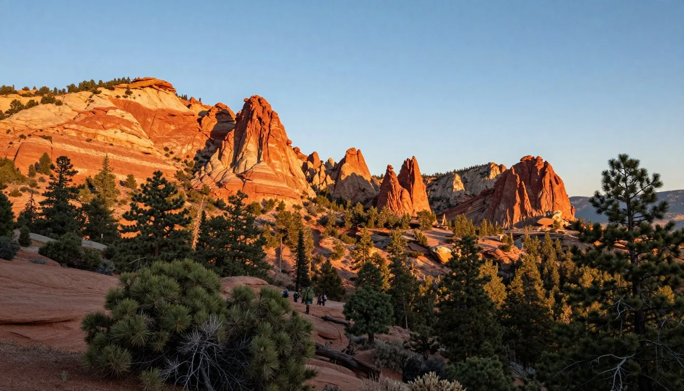
The climb to Cedar Mountain summit defines the wilderness experience. This moderate hike covers approximately 8 kilometers (5 miles) round trip with 762 meters (2,500 feet) of elevation gain.
The trail begins on dirt roads before transitioning to animal trails. Route-finding skills help navigate sections where the path becomes faint. The ridge offers spectacular views spanning dozens of miles across the West Desert.
Reaching the summit rewards hikers with 360-degree panoramas. On clear days, visibility extends to the Wasatch Range in the east and Nevada mountains to the west. The prominence of this peak makes it a landmark across the region.
Ridge Walking and Exploration
Advanced hikers extend trips by following ridges connecting multiple peaks. These routes require navigation skills and stamina for extended elevation changes on rugged terrain.
Wildlife sightings increase along less-traveled ridges. Deer, pronghorn antelope, and various raptors inhabit the area. Early morning and evening hours provide best viewing opportunities.

Photography Opportunities
Sunrise and sunset paint the desert landscape in spectacular colors. Photographers capture dramatic lighting on ridge formations and distant mountain ranges from elevated viewpoints.
Spring wildflowers add color to normally brown slopes. The contrast between green growth and rocky terrain creates compelling images along the trail and near the summit.
Stargazing in Dark Skies
Minimal light pollution makes Cedar Mountain ideal for astronomy. Overnight campers enjoy pristine views of the Milky Way, planets, and meteor showers throughout the year.
The remote location and high elevation combine to create exceptional viewing conditions. Bring star charts or astronomy apps to identify constellations and celestial objects.
Museums, Cultural Spots & Festivals

Cultural attractions exist primarily in nearby towns rather than within the wilderness itself. These sites provide context for understanding the region’s mining and ranching heritage.
Regional History
The Tooele Pioneer Museum showcases local history from Native American inhabitants through mining booms and settlement periods. Exhibits include mining equipment, pioneer artifacts, and historical photographs documenting the area’s development.
Vernon’s history reflects ranching traditions that continue today. Small community displays occasionally appear during local celebrations, though permanent facilities don’t exist in this tiny settlement.
Native American Heritage
The Goshute people traditionally inhabited lands including areas around cedar mountain. Their seasonal migration patterns included mountain regions for hunting and gathering.
Archaeological sites exist throughout the West Desert, though most are protected and not accessible to visitors. Respect all artifacts and rock art encountered in the wilderness.
Nature & Outdoor Experiences

The natural environment defines every Cedar Mountain Wilderness experience. From desert ecology to mountain ecosystems, the area offers diverse outdoor learning opportunities.
Flora and Fauna
Sagebrush dominates lower elevations, giving way to juniper and scattered cedars at middle elevations. Despite the name “cedar mountain,” true cedars are absent. Local junipers historically were misidentified as cedars by early settlers.
Wildlife adapts to harsh conditions through remarkable strategies. Mule deer browse on available vegetation. Coyotes patrol animal trails hunting smaller prey. Golden eagles soar on thermals rising from sun-heated slopes.

Geological Features
The mountain’s formation tells stories of ancient volcanic activity and erosion. Rocky outcrops display varied mineral compositions creating colorful bands across cliff faces.
Fossils occasionally appear in sedimentary layers. While collecting is prohibited in wilderness areas, observation provides windows into prehistoric environments that existed millions of years ago.
Seasonal Changes
Spring transforms brown slopes into green carpets as winter moisture triggers plant growth. This brief window lasts only weeks before summer heat returns the landscape to dormant browns and grays.
Fall brings subtle color changes to vegetation. The lack of deciduous trees means autumn displays remain muted compared to mountain ranges farther east.
Backcountry Skills Development
Cedar Mountain provides excellent terrain for practicing navigation skills. The combination of trails, animal paths, and off-trail travel challenges hikers to read topography and use compass and GPS effectively.
The remote setting teaches self-reliance. Visitors develop problem-solving abilities and confidence in their capacity to handle challenges far from assistance.
✓ Check 30,000+ Local Sightseeing Tours Worldwide
Travel With Children

Taking children to Cedar Mountain Wilderness requires careful consideration of safety and ability levels. The remote location and challenging terrain suit older children and teenagers better than young kids.
Age Recommendations
Children aged 10 and above with hiking experience can potentially manage portions of the trail. The elevation gain and distance challenge younger or inexperienced hikers regardless of fitness levels.
Consider shorter explorations near the trailhead rather than summit attempts with young children. The area offers opportunities for nature observation, rock exploration, and outdoor skills learning without committing to the full route.
Safety Considerations
The isolated location means no quick access to medical care. Minor injuries that would be inconveniences elsewhere become serious concerns when hours from assistance.
Adequate water becomes critical for children who may not recognize dehydration symptoms. Pack extra water beyond normal calculations and monitor consumption throughout the hike.
Sun exposure at elevation intensifies quickly. Apply sunscreen frequently, provide hats with neck protection, and schedule breaks in any available shade.
Educational Opportunities
The wilderness provides excellent outdoor education experiences. Children learn about desert ecosystems, weather patterns, navigation skills, and Leave No Trace principles through direct experience.
Involving kids in trip planning teaches responsibility and decision-making. Let them help with map reading, weather checking, and gear preparation to build investment in the adventure.
Parent Guidance: Honestly assess your children’s abilities before committing to this hike. The consequences of overestimating capabilities can be serious in this remote environment.
Money Saving Tips

Visiting Cedar Mountain Wilderness naturally costs less than typical tourist destinations. The lack of entrance fees, attractions, and services means lower overall expenses for prepared travelers.
Free Camping Options
Dispersed camping on BLM land eliminates accommodation costs entirely. This free option suits self-sufficient adventurers comfortable with primitive conditions and basic outdoor skills.
Arrive with all necessary gear and supplies. Renting equipment for one trip often costs more than staying in budget motels. Consider borrowing gear from experienced friends for first visits.
Food and Supply Savings
Shop at supermarkets in larger towns rather than convenience stores along the route. Prices drop significantly at full-service grocers compared to small rural shops.
Prepare meals at home and pack them in reusable containers. This approach costs less than purchasing pre-packaged backpacking meals while offering more food variety and better nutrition.
Transportation Efficiency
Carpooling with friends splits fuel costs while providing safety benefits through group travel. The long drive becomes more enjoyable with companions sharing the experience.
Rent vehicles in Salt Lake City where competition keeps prices lower. Airport rentals often include better insurance terms and newer vehicles than smaller rental offices.
Timing Your Visit
Shoulder seasons (May and October) offer pleasant weather without peak summer demand. Lodging prices in nearby towns drop outside June through August when most families travel.
Midweek visits mean less crowded trailheads and lower accommodation rates. Tuesday through Thursday rates often cost 20-30% less than weekend pricing.
Safety, Etiquette & Local Customs

Wilderness safety requires preparation, awareness, and respect for the environment. Cedar Mountain’s remote character means visitors must be self-reliant and capable of handling emergencies independently.
Essential Safety Practices
Always inform someone of your plans, including route, expected return time, and vehicle description. This simple step dramatically improves rescue chances if problems arise.
Carry the ten essentials: navigation tools, sun protection, extra clothing, illumination, first aid supplies, fire starting materials, repair kit, nutrition, hydration, and emergency shelter. Each item addresses specific wilderness risks.
Cell phone service doesn’t exist throughout most of the area. Satellite communication devices provide emergency contact capability but should not replace proper preparation and skills.
Weather-Related Hazards
Lightning strikes pose serious danger on exposed ridges during thunderstorms. Descend immediately when storms approach. Don’t wait for rain to begin, as lightning often strikes before precipitation reaches the ground.
Summer heat causes rapid dehydration at elevation. Consume water regularly rather than waiting until thirsty. Electrolyte replacement becomes important during strenuous activity in hot conditions.
Hypothermia can develop even in summer if storms bring cold rain and wind. Pack insulating layers and rain protection regardless of forecast.
Wildlife Interactions
Encounters with large wildlife rarely occur but remain possible. Make noise while hiking to avoid surprising animals. Give wildlife space to retreat without feeling cornered or threatened.
Rattlesnakes inhabit lower elevations, especially during warmer months. Watch where you place hands and feet when scrambling over rocks. Most bites occur when people accidentally touch or step near snakes.
Leave No Trace Principles
Pack out all trash, including organic waste like orange peels and apple cores. These items take years to decompose in arid environments and attract wildlife to human areas.
Use established campsites when available to minimize impact. If camping in pristine areas, move camp each night to prevent creating new damage from concentrated use.
Human waste disposal requires proper technique in this dry environment. Dig catholes 15-20 centimeters (6-8 inches) deep and at least 61 meters (200 feet) from water, trails, and campsites. Pack out toilet paper in sealed bags.
Local Customs and Etiquette
Rural Utah communities value self-reliance and preparedness. Locals expect visitors to take responsibility for their safety rather than requiring rescue due to poor planning.
Respect private property boundaries. Many roads cross private ranch land before reaching public wilderness. Stay on designated routes and close all gates you open.
Ranching remains active in surrounding areas. Livestock use public lands throughout the region. Give cattle and sheep plenty of space and never approach or disturb herds.
Emergency Contact: In serious emergencies, call 911. Be prepared to provide detailed location information. GPS coordinates help rescue teams locate you more quickly than vague descriptions.
For non-emergency assistance, contact the Juab County Sheriff’s Office:
Visitor Comments About Cedar Mountain Wilderness

“The solitude on Cedar Mountain exceeded all expectations. We hiked the entire trail to the summit without seeing another person. The ridge walk challenged our navigation skills, but reaching the top made every step worthwhile. Views extended for what felt like hundreds of miles across the West Desert. This wilderness area deserves more recognition for its raw beauty.”
“I’ve completed many Utah peaks, and Cedar Mountain ranks among the most rewarding. The moderate difficulty makes it accessible without being easy. The dirt road approach adds adventure to the whole experience. Spring wildflowers along the lower slopes provided unexpected beauty. Just be prepared for primitive conditions and bring everything you need. No facilities means true wilderness.”
“Our family found Cedar Mountain perfect for teaching teenagers about backcountry skills. The trail tests abilities without extreme danger if you’re prepared. My kids learned navigation, water management, and self-reliance. The prominence of this peak means you can see your goal from miles away, which motivated them throughout the hike. We’ll definitely return for another adventure.”
Additional Nearby Destinations

The West Desert region surrounding Cedar Mountain offers additional wilderness experiences for adventurers seeking extended exploration beyond a single peak.
Simpson Springs
This historic site served as a Pony Express station along the original route. Located approximately 56 kilometers (35 miles) northwest of Cedar Mountain, the area provides camping, a maintained spring, and interpretive displays about communication history across the frontier.
The dirt road conditions resemble those accessing Cedar Mountain. High-clearance vehicles handle the route easily during dry conditions.
Little Sahara Recreation Area
Sand dunes stretch across thousands of acres south of Cedar Mountain. This popular OHV destination attracts off-road enthusiasts year-round. The contrast between dune landscapes and mountain wilderness makes for interesting regional variety.
Facilities at Little Sahara include campgrounds with water, restrooms, and garbage service. The developed infrastructure provides a stark contrast to primitive Cedar Mountain camping.
Fish Springs National Wildlife Refuge
Wetlands in the midst of desert create unexpected wildlife habitat west of Cedar Mountain. Migratory birds use this oasis during spring and fall migrations. The refuge offers wildlife viewing, photography, and birding opportunities.
The drive to Fish Springs follows good dirt roads through remote territory. Plan extra time for the scenic route and potential wildlife sightings along the way.
✓ Check 30,000+ Local Sightseeing Tours Worldwide
Great Basin National Park
While farther west in Nevada, this national park provides alpine experiences at Wheeler Peak. Ancient bristlecone pines, limestone caves, and glacial features offer completely different ecosystems from Cedar Mountain’s desert environment.
The drive takes approximately three hours from Cedar Mountain. Consider multi-day trips combining destinations for comprehensive Great Basin exploration.
Nearby Peak Bagging Opportunities
Several other prominent peaks rise throughout the West Desert. King Top, Swasey Peak, and Notch Peak attract peak baggers seeking to complete Utah prominence lists.
Each mountain presents unique challenges and rewards. Combining multiple peak ascents during single trips maximizes the value of long drives to remote trailheads.
Practical Travel Tips
Vehicle Preparation
Inspect your vehicle thoroughly before departure. Check tire pressure, fluid levels, and spare tire condition. Carry basic tools, jumper cables, and tire repair equipment for handling minor roadside issues.
A full-size spare tire proves essential on rough dirt roads where flats occur more frequently. Compact temporary spares don’t handle continued rough road travel after installation.
Communication Planning
Download offline maps for the entire region before leaving cell coverage. GPS devices work without cellular service, but mapping apps require downloaded data for displaying base maps.
Consider satellite communication devices for extended trips. These units allow emergency communication and provide peace of mind for families worried about your safety in remote areas.
Water Strategy
Calculate water needs conservatively and add 50% as safety margin. Each person requires minimum 3-4 liters daily for drinking and cooking in desert conditions. Physical activity increases requirements significantly.
Carry water in multiple containers rather than single large vessels. This strategy prevents total loss if one container leaks or breaks. Collapsible containers save space when empty.
Seasonal Considerations
Spring visits require extra attention to weather forecasts. Late season storms bring snow to higher elevations unexpectedly. Pack winter layers even when valley temperatures feel mild.
Fall conditions generally provide more stable weather patterns. However, daylight hours shorten significantly by late October, requiring earlier start times to complete hikes before darkness.
Navigation Tools
Carry both GPS devices and paper maps. Technology fails, batteries die, and devices break. Paper maps work regardless of conditions and require no power source.
Learn to use compass and map together before relying on these skills in the field. Practice in familiar areas builds confidence for wilderness navigation.
Photography Equipment
Protect camera gear from dust pervading the desert environment. Use protective bags or covers to shield equipment during transport on dirt roads and while hiking.
Wide-angle lenses capture expansive views from summit and ridge locations. Telephoto lenses help photograph distant peaks and any wildlife encountered during the trip.
Physical Preparation
Train for elevation gain by hiking stairs, hills, or mountains with progressively heavier packs. The 762-meter (2,500-foot) climb challenges even fit hikers unaccustomed to sustained ascent.
Acclimatize to altitude if traveling from sea level. Spend time at intermediate elevations before attempting peak ascents to reduce altitude sickness risk.
Group Size Recommendations
Parties of 2-4 people balance safety and minimal impact ideally. Solo travel increases risks substantially in this remote environment. Groups larger than six create more environmental impact and complicate logistics.
Establish clear communication plans within groups. Agree on pace, rest frequency, and decision-making processes before starting the hike to prevent conflicts during challenging moments.
Location
Cedar Mountain Wilderness is located in Utah’s remote West Desert, accessible via dirt roads from Highway 36.
Your Adventure Awaits in Utah’s Hidden Wilderness
Cedar Mountain Wilderness stands as a testament to Utah’s vast and varied wild lands. This remote peak offers experiences increasingly rare in our connected world: true solitude, self-reliance challenges, and unfiltered natural beauty.
The moderate trail tests your abilities without requiring technical skills. The summit rewards effort with views spanning Utah’s dramatic West Desert landscape. Each step along the ridge connects you more deeply to the wild character that defines this special place.
Whether you seek personal challenge, photography opportunities, or simply escape from crowded trails, Cedar Mountain delivers authentic wilderness adventure. Pack carefully, plan thoroughly, and prepare for an experience that will stay with you long after you return to pavement and cell service.
The mountain waits patiently for those willing to venture beyond comfort zones into genuine backcountry. Your Cedar Mountain story begins the moment you turn onto that first dirt road heading west into Utah’s magnificent emptiness.