Hotels by Trip.com
Flights by Trip.com
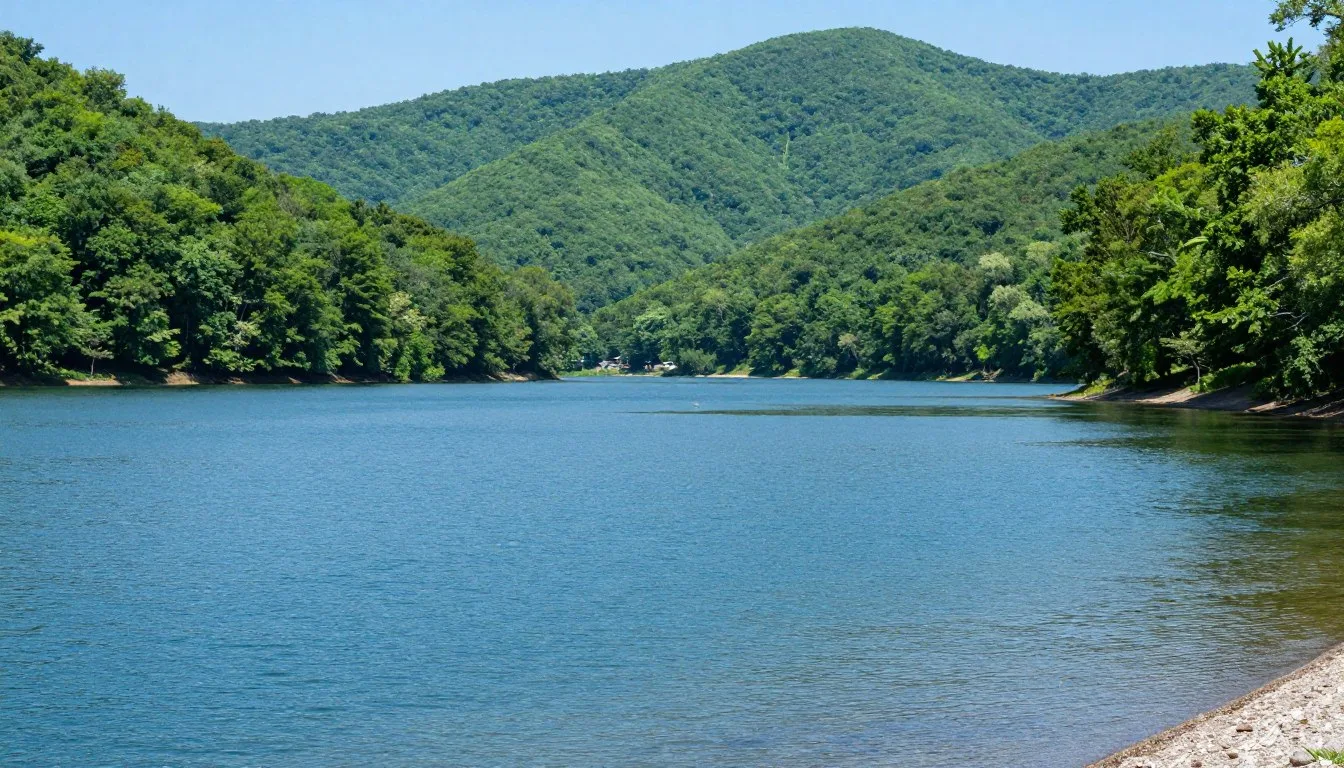
Every year, more than 200,000 travelers wind their way along a stunning 43-mile mountain road that connects two states and offers some of the most breathtaking views in the southeastern United States. The name "Cherohala" combines "Cherokee" and "Nantahala," representing the two national forests this remarkable skyway traverses.
This scenic drive climbs to elevations exceeding 1,676 meters (5,400 feet). It showcases untouched wilderness across Cherokee National Forest in Tennessee and Nantahala National Forest in North Carolina. The journey takes travelers through diverse ecosystems and offers spectacular vistas at every turn.
Whether you ride a motorcycle along the winding curves, drive leisurely to photograph fall colors, or stop to hike pristine mountain trails, the Cherohala Skyway promises an unforgettable experience. This guide covers everything from planning your trip to discovering hidden gems along the way.
Getting There & Planning Your Journey

The beginning of Cherohala Skyway starts in Tellico Plains, Tennessee, a charming mountain town that serves as the eastern gateway to this scenic route. From Tellico Plains, the road winds westward through the Cherokee National Forest before crossing into North Carolina.
The closest major airport is McGhee Tyson Airport in Knoxville, located approximately 95 kilometers (59 miles) north of Tellico Plains. From Knoxville, the drive takes about 90 minutes via Highway 411 South. Travelers can rent vehicles at the airport to begin their journey.
Chattanooga Metropolitan Airport offers another option, situated about 105 kilometers (65 miles) southwest of Tellico Plains. This route provides scenic views through the Tennessee Valley. Both airports offer car rental services and easy highway access to the area.
Skyway Visitor Center Contact: The visitor center in Tellico Plains provides current road conditions, weather updates, and travel recommendations. Staff members offer helpful advice about the best overlooks and side road attractions along Cherohala Skyway.
Plan for at least three to four hours to drive the entire Cherohala Skyway without stops. However, most travelers spend a full day to enjoy overlooks, take photographs, and explore side roads. The route features numerous pulloffs where you can safely stop to appreciate the views.
The road surface is well-maintained, with smooth pavement throughout most sections. However, the winding nature of the drive requires attention and careful navigation. Motorcycle enthusiasts particularly enjoy the curves and elevation changes that make this road famous among riders.
Best Time to Visit & Weather Tips

Recommended Seasons for Your Visit
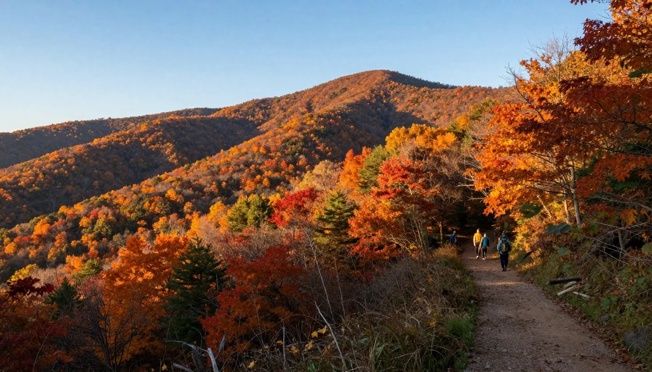
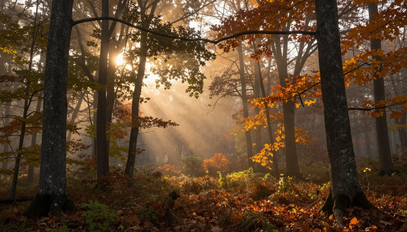
Fall stands out as the most popular season along Cherohala Skyway. From late September through early November, the mountains explode in brilliant colors. Peak fall foliage typically occurs during mid-October when the entire landscape transforms into a tapestry of reds, oranges, and golds.
During fall, temperatures range from 10°C to 18°C (50°F to 65°F) at lower elevations. Higher elevations along the skyway can be 6°C to 8°C (10°F to 15°F) cooler. Visitors should bring layers to adjust for temperature changes as they gain elevation.
Summer months from June through August offer excellent conditions for the drive. Temperatures at lower elevations reach 26°C to 29°C (80°F to 85°F), while the higher elevations provide a refreshing escape with temperatures around 21°C to 24°C (70°F to 75°F). This season is perfect for hiking and picnic stops.
Spring brings wildflowers and rushing waterfalls as snowmelt feeds mountain streams. From April through May, temperatures climb from 13°C to 21°C (55°F to 70°F). The forest comes alive with new growth, and the area attracts fewer crowds than fall.
Seasons to Approach with Caution
Winter months from December through March present challenges along Cherohala Skyway. Snow and ice frequently close portions of the road at higher elevations. The skyway does not receive winter maintenance like major highways, so closures can last several days after storms.
If you visit during winter, check current conditions before your trip. Temperatures can drop below -7°C (20°F) at higher elevations, with significant snowfall possible. Many facilities near Tellico Plains close or operate on limited schedules during these months.
Notable Annual Festivals
The Cherohala Skyway Fall Festival takes place each October in Tellico Plains. This event celebrates the peak fall colors with local crafts, food vendors, and live music. The festival attracts thousands of visitors who combine festival activities with scenic drives along Cherohala Skyway.
Contact the Monroe County Welcome Center at the beginning of Cherohala Skyway for specific festival dates and details. The welcome center staff provides information about road conditions and helps visitors plan their journey during busy festival weekends.
The Tellico Plains Mountain Festival occurs in May, offering a different perspective on the area. Spring wildflowers bloom throughout the Cherokee National Forest, and the festival showcases regional arts, crafts, and mountain culture.
Weather Advisory: Mountain weather changes rapidly along Cherohala Skyway. Fog can roll in quickly, reducing visibility to just a few meters. Always check weather forecasts before your trip and be prepared to adjust plans if conditions deteriorate.
Getting Around Locally

Personal vehicles provide the best way to experience Cherohala Skyway and the surrounding area. No public transportation serves this remote mountain region. Rental cars from Knoxville or Chattanooga airports give visitors the freedom to explore at their own pace.
Motorcycles are extremely popular along Cherohala Skyway. The smooth pavement and sweeping curves attract riders from across the country. Many motorcycle groups plan multi-day trips that include the nearby Tail of the Dragon and other famous riding roads in the area.
The main route requires no special vehicle capabilities during good weather. Standard passenger cars handle the road easily. However, some side roads leading to trailheads or remote overlooks may require higher clearance vehicles, especially after rain.
Fuel availability is limited once you leave Tellico Plains. The town offers several gas stations, but no fuel services exist along the 43-mile stretch of Cherohala Skyway itself. Fill your tank before beginning the drive to avoid running low in the mountains.
Cell phone service is spotty or nonexistent along much of Cherohala Skyway. Download maps and directions before you leave areas with reliable service. Inform someone of your travel plans and expected return time, especially if hiking or exploring side roads.
Where to Stay

Tellico Plains serves as the primary base for visitors exploring Cherohala Skyway. This small town offers several motels, cabins, and bed-and-breakfast establishments. Most accommodations provide comfortable, budget-friendly options within minutes of the beginning of Cherohala Skyway.
Local motels in Tellico Plains offer basic amenities and convenient access to restaurants and shops. Rates typically range from moderate to budget-friendly, especially during weekdays. Weekend rates during fall increase significantly due to high demand from leaf-peepers.
Cabin rentals near Tellico Plains provide more privacy and space for families or groups. Many cabins feature full kitchens, multiple bedrooms, and outdoor spaces perfect for enjoying mountain evenings. These rentals often require minimum stays during peak seasons.
Robbinsville, North Carolina, sits at the western end of Cherohala Skyway. This small town offers additional lodging options for travelers who want to experience the skyway from both directions. The area features several small inns and cabin communities.
For those seeking a more immersive nature experience, camping opportunities exist throughout the Cherokee National Forest near Cherohala Skyway. Indian Boundary Recreation Area offers developed campgrounds with amenities, while dispersed camping is available in designated forest service areas.
Booking Tip: Reserve accommodations well in advance if visiting during fall. Many establishments near Tellico Plains book solid weeks or even months ahead of peak foliage season. Early reservations ensure the best selection and rates.
The Indian Boundary area near Cherohala Skyway provides camping with lake access. The campground features restrooms, water, and picnic tables. Campers enjoy proximity to hiking trails and swimming areas during summer months.
Dining & Local Cuisine

Tellico Plains offers a selection of local restaurants serving traditional Southern cuisine and American comfort food. These family-owned establishments provide hearty meals perfect after a day exploring Cherohala Skyway. Most restaurants feature friendly service and reasonable prices.
Breakfast options in the area emphasize traditional Southern favorites. Local diners serve biscuits and gravy, country ham, eggs, and strong coffee. These establishments open early to accommodate travelers eager to start their drive along Cherohala Skyway at sunrise.
Barbecue restaurants near Tellico Plains offer slow-smoked meats prepared in traditional Tennessee style. Pulled pork, ribs, and brisket come with classic sides like coleslaw, baked beans, and cornbread. Many places prepare their meats overnight using hickory or oak wood.
Pizza and casual dining establishments provide options for families with children. These restaurants offer varied menus beyond Southern specialties, including burgers, sandwiches, and salads. Several places in Tellico Plains feature outdoor seating during pleasant weather.
No dining facilities exist along the 43-mile stretch of Cherohala Skyway itself. Travelers should pack snacks, water, and perhaps a picnic lunch to enjoy at one of the scenic overlooks. Several spots along the road feature picnic tables with mountain views.
Local grocers in Tellico Plains stock supplies for those staying in cabins or camping near Cherohala Skyway. These stores carry basics plus regional specialties. Purchasing supplies in town saves time and ensures you have everything needed for your mountain adventure.
Attractions, Sightseeing & Activities

Scenic Overlooks and Viewpoints
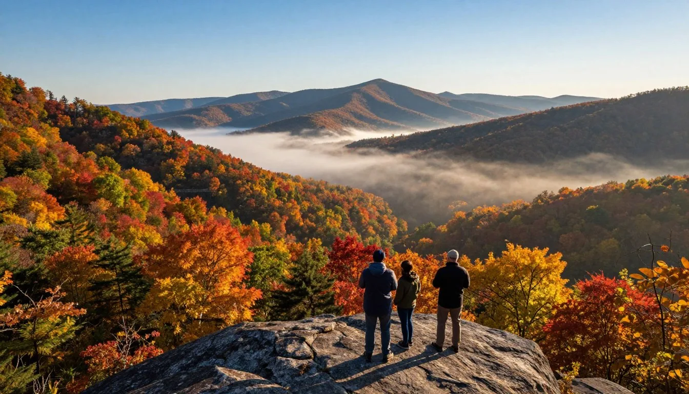
More than a dozen official overlooks line Cherohala Skyway, each offering unique perspectives on the surrounding mountains. These pulloffs provide safe places to stop, take photographs, and simply appreciate the vast wilderness stretching in all directions.
The highest point along Cherohala Skyway reaches 1,676 meters (5,400 feet) at Santeetlah Gap. This overlook provides 360-degree views of the surrounding peaks. On clear days, visibility extends for dozens of miles across Tennessee and North Carolina.
Hooper Bald stands as one of the most accessible high-elevation destinations along the skyway. A short side road leads to a grassy bald with panoramic views. This spot attracts photographers during sunrise and sunset when golden light illuminates the mountain ridges.
Many overlooks along Cherohala Skyway feature informational signs describing the local ecology, history, and geography. These educational displays help visitors understand the unique characteristics of the southern Appalachian ecosystem.
Photography Opportunities
Fall photography along Cherohala Skyway attracts professional and amateur photographers from around the world. The combination of winding road, mountain vistas, and brilliant foliage creates countless composition opportunities. Early morning fog adds dramatic atmosphere to images.
Wildlife photography is possible throughout the Cherokee National Forest areas near Cherohala Skyway. White-tailed deer, wild turkeys, and various bird species inhabit the forests. Patient observers might spot black bears, though these encounters are relatively rare.

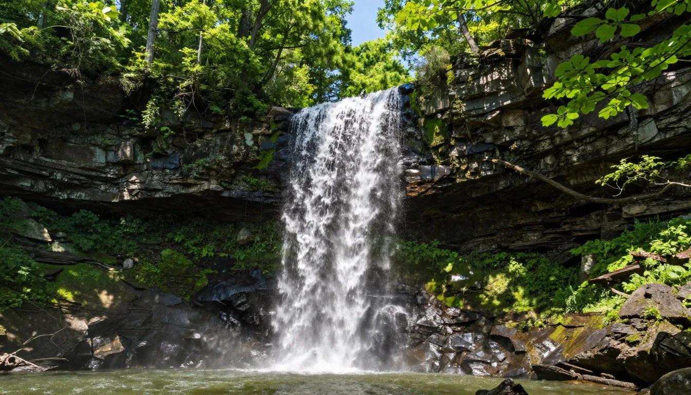
Bald River Falls
A short side road from Cherohala Skyway leads to Bald River Falls, one of Tennessee's most beautiful waterfalls. The falls cascade approximately 30 meters (100 feet) over a series of rock ledges. A viewing platform provides excellent vantage points for photography.
The drive to Bald River Falls follows Bald River through pristine forest. This side trip adds about 30 minutes to your journey but rewards visitors with one of the area's most photogenic natural features. The falls flow year-round, with highest volume during spring.
Indian Boundary Recreation Area
Indian Boundary Lake covers approximately 15 hectares (38 acres) and offers swimming, fishing, and paddling opportunities. The recreation area sits just minutes from the beginning of Cherohala Skyway near Tellico Plains. A 5-kilometer (3-mile) loop trail circles the lake through beautiful forest.
The lake area features a small beach for swimming during summer months. Families enjoy the calm waters and designated swimming area. Fishing for bass and bream provides entertainment for anglers of all skill levels.
Museums, Cultural Spots & Festivals

The Charles Hall Museum in Tellico Plains preserves the history of the Cherohala Skyway construction and the surrounding region. Exhibits detail the 34-year effort to complete this scenic highway. Photographs and artifacts tell stories of the communities affected by the project.
Regional cultural heritage reflects the Cherokee people who originally inhabited these mountains. The name Cherohala honors this connection to Cherokee National Forest. Learning about this history adds depth to the scenic drive experience along Cherohala Skyway.
Tellico Plains hosts various community events throughout the year that showcase Appalachian culture. Traditional music, crafts, and storytelling keep mountain heritage alive. Visitors who time their trips to coincide with these events gain insight into local traditions.
The area surrounding Cherohala Skyway played a role in American frontier history. Early settlers, including Scottish and Irish immigrants, established farms and communities in these isolated valleys. Their descendants maintain many traditions passed down through generations.
Nature & Outdoor Experiences

Hiking Trails
Dozens of hiking trails branch off from Cherohala Skyway and nearby forest roads. These trails range from easy walks to challenging wilderness treks. The Cherohala Skyway intersects with the Appalachian Trail near its western end, offering opportunities for experienced hikers.
The Bald River Trail follows a pristine mountain stream through old-growth forest. This moderate 6-kilometer (3.7-mile) trail showcases the diversity of southern Appalachian ecosystems. Hikers encounter numerous small cascades and swimming holes along the way.
Bob Stratton Bald Trail provides access to a high-elevation grassy bald with spectacular views. The round-trip hike covers approximately 5 kilometers (3 miles) with moderate elevation gain. Wildflowers bloom abundantly on the bald during spring and early summer.
Make sure to stop at trailheads that interest you, but remember that many trails require several hours to complete. Bring adequate water, snacks, and appropriate footwear. Trail conditions can be muddy after rain, especially at higher elevations along Cherohala Skyway.
Wildlife Watching
The Cherokee National Forest surrounding Cherohala Skyway supports diverse wildlife populations. Early morning and evening hours offer the best opportunities for animal sightings. Deer frequently graze near the road at dawn and dusk.
Black bears inhabit the forests along Cherohala Skyway, though encounters are uncommon. If you spot a bear, maintain a safe distance and never approach or feed wildlife. Store food properly when camping, and follow forest service guidelines for wildlife safety.

Scenic Picnic Spots
Several overlooks along Cherohala Skyway feature picnic tables where visitors can enjoy meals with mountain views. These spots provide perfect lunch breaks during your drive. Pack food from Tellico Plains or bring supplies from home for an elevated dining experience.
The combination of fresh mountain air, stunning vistas, and good food creates memorable moments. Many families make picnicking along the skyway a central part of their visit. Choose overlooks that offer both views and shade during hot summer months.
Fall Foliage Viewing
The fall color display along Cherohala Skyway ranks among the finest in the southeastern United States. Multiple tree species create a complex palette of colors. Oaks, maples, hickories, and birches contribute reds, oranges, yellows, and purples to the landscape.
Color changes typically begin at higher elevations in late September and progress downward through October. This extended season means visitors can potentially catch peak colors somewhere along Cherohala Skyway throughout a several-week period.
Weekdays offer better experiences than weekends during peak fall season. Traffic can be heavy on Saturday and Sunday afternoons as people flock to see the spectacular views. Consider visiting mid-week for a more peaceful drive with easier parking at overlooks.
Travel With Children

The drive along Cherohala Skyway fascinates children with its winding curves and ever-changing scenery. The journey feels like an adventure as the road climbs into the clouds. Kids enjoy counting overlooks and spotting wildlife along the way.
Plan for frequent stops when traveling with young children. The many pulloffs and overlooks provide opportunities to stretch legs and burn energy. Short walks at scenic areas break up the drive and keep everyone engaged.
Indian Boundary Lake near Tellico Plains offers family-friendly recreation. The swimming beach, playgrounds, and easy hiking trails provide entertainment for various ages. Children particularly enjoy feeding ducks and exploring the shoreline.
Educational opportunities abound along Cherohala Skyway. Teach children about mountain ecosystems, forest types, and elevation changes. The dramatic altitude gain provides lessons about how environment changes with elevation. Encourage kids to observe different plants and trees at various heights.
Pack activities for the drive such as nature scavenger hunts or photography challenges. Give older children cameras to document their favorite views along Cherohala Skyway. These activities create engagement and lasting memories of the trip.
Safety is essential when traveling with children in mountain areas. Keep young ones close at overlooks, as many lack barriers. The winding road requires that all passengers remain seatbelted throughout the drive. Teach children to respect wildlife by observing from a distance.
Money Saving Tips
Experiencing Cherohala Skyway costs nothing, as no entrance fees or tolls exist along the entire route. The road remains free and open to all visitors year-round, weather permitting. This makes it one of the most budget-friendly scenic drives in the United States.
Pack your own food and drinks rather than relying on restaurants for every meal. The overlooks with picnic tables provide perfect spots for budget-friendly dining with unbeatable views. Grocery stores in Tellico Plains offer supplies at reasonable prices.
Visit during shoulder seasons like late spring or early fall to find lower accommodation rates near Tellico Plains. Hotels and cabins charge premium prices during peak fall foliage in mid-October. Traveling just a few weeks earlier or later can reduce lodging costs significantly.
Camping in the Cherokee National Forest offers the most economical overnight option. Developed campgrounds charge modest fees, while dispersed camping in permitted areas costs nothing. Both options provide direct access to nature and proximity to Cherohala Skyway.
Fill your fuel tank in larger towns before reaching Tellico Plains, where gas prices may be higher due to limited competition. Topping off in Knoxville or Chattanooga can save several dollars per tank. The fuel efficiency advantage of coasting downhill sections also helps stretch your budget.
Many hiking trails along Cherohala Skyway are free to access. These provide hours of entertainment without spending money. Swimming at Indian Boundary Lake is free, though parking may require a small forest service fee during peak season.
Budget-Friendly Tip: Wednesday through Thursday visits often secure better rates at area accommodations. Many establishments near Tellico Plains offer midweek specials to attract guests during slower periods. Combining midweek lodging with free activities along Cherohala Skyway creates an affordable getaway.
Safety & Local Customs

Drive carefully along Cherohala Skyway, as the road features numerous sharp curves and significant elevation changes. Posted speed limits reflect safe speeds for conditions. Resist the temptation to speed on straight sections, as another curve always lies just ahead.
Watch for motorcycles, which are extremely common along Cherohala Skyway. Riders often lean into curves, so give them plenty of space. Be especially cautious when passing or being passed by groups of motorcycles.
Wildlife can appear suddenly on the road, particularly during dawn and dusk hours. Deer are common along Cherohala Skyway and can cause serious accidents. Stay alert and reduce speed in areas with limited visibility around curves.
Cell phone coverage is unreliable or absent along much of Cherohala Skyway. Carry emergency supplies including water, basic tools, a first-aid kit, and warm clothing. If you experience vehicle trouble, you may need to wait for another traveler to pass.
Weather can change rapidly at higher elevations along the skyway. Fog can reduce visibility to nearly zero within minutes. If you encounter thick fog, use low-beam headlights and reduce speed significantly. Consider waiting at a pulloff for conditions to improve.
Local customs in the Tellico Plains area reflect traditional Southern hospitality. People are generally friendly and helpful to visitors. Take time to chat with locals, who often share valuable tips about the best overlooks and side roads along Cherohala Skyway.
Respect the natural environment by following Leave No Trace principles. Pack out all trash, stay on designated trails, and never feed wildlife. The pristine condition of areas near Cherohala Skyway depends on visitors treating the forest with care.
Visitor Comments About Cherohala Skyway
"The drive exceeded every expectation. Each curve revealed another stunning vista. We stopped at nearly every overlook and still wished we had more time. The fall colors were absolutely spectacular, making this easily one of the most beautiful drives we have ever experienced."
"As a motorcycle enthusiast, Cherohala Skyway ranks among my favorite roads anywhere. The smooth pavement, sweeping curves, and incredible scenery combine perfectly. We rode it three times during our visit and discovered something new each trip. The overlooks provide perfect rest stops with views that never get old."
"Our family loved every minute exploring this area. The kids enjoyed spotting wildlife and playing at Indian Boundary Lake. The drive along the skyway kept everyone engaged with constant changes in scenery. Tellico Plains provided a comfortable base with friendly people and good food. We are already planning our return visit."
Additional Nearby Destinations

Great Smoky Mountains National Park lies approximately 64 kilometers (40 miles) northeast of Tellico Plains. This world-famous park attracts millions of visitors annually to see its diverse wildlife, historic buildings, and stunning mountain scenery. The park offers hundreds of kilometers of hiking trails.
The Tail of the Dragon, located about 48 kilometers (30 miles) west of Cherohala Skyway, is legendary among motorcycle riders. This 18-kilometer (11-mile) section of US Route 129 features 318 curves. Many riders combine trips to both the Dragon and Cherohala Skyway during visits to the area.
Chattanooga, Tennessee, sits about 105 kilometers (65 miles) southwest of Tellico Plains. This revitalized city offers attractions including the Tennessee Aquarium, Rock City, and Ruby Falls. Chattanooga provides urban amenities and entertainment options to complement mountain adventures along Cherohala Skyway.
Knoxville, Tennessee, located 95 kilometers (59 miles) north of Tellico Plains, offers museums, restaurants, and University of Tennessee sporting events. The city serves as a logical starting or ending point for trips to Cherohala Skyway and surrounding attractions.
Ocoee River, famous for whitewater rafting, flows about 32 kilometers (20 miles) south of Tellico Plains. Commercial rafting companies operate throughout the summer season. The river hosted Olympic whitewater events in 1996 and continues to attract paddlers seeking exciting rapids.
Joyce Kilmer Memorial Forest in North Carolina preserves one of the largest remaining old-growth forests in the eastern United States. This pristine forest lies near the western end of Cherohala Skyway. A moderate loop trail winds through towering trees that predate European settlement.
Practical Travel Tips

Start your drive along Cherohala Skyway early in the morning to avoid afternoon crowds and enjoy the best light for photography. Sunrise from the higher elevations creates magical moments as mist lifts from the valleys below.
Download offline maps of the Cherohala Skyway route before leaving areas with reliable cell service. GPS signals work throughout most of the drive, but data connections for loading maps may not. Having offline access ensures navigation even without cellular coverage.
Dress in layers regardless of season. Temperature variations between Tellico Plains and the highest points along Cherohala Skyway can exceed 11°C (20°F). What feels comfortable at the beginning of the drive may be quite different at higher elevations.
Bring binoculars for wildlife watching and distant view appreciation. The vast perspectives along Cherohala Skyway reveal details that enhance the experience. Many overlooks provide views extending dozens of kilometers across multiple mountain ranges.
Allow plenty of time for your journey. Rushing defeats the purpose of driving Cherohala Skyway. The experience rewards those who stop frequently, explore side roads, and simply absorb the peaceful mountain atmosphere.
Check current road conditions before traveling, especially during winter, spring, or after severe weather. The forest service provides updates about closures or hazardous conditions. Local establishments near Tellico Plains also share current information with visitors.
Respect other travelers by parking completely off the roadway at overlooks. The narrow shoulders and continuous curves make partially-blocked pulloffs dangerous. Ensure your vehicle is fully in designated parking areas before exiting.
Carry water and snacks, as no services exist along the 43-mile stretch of Cherohala Skyway. The drive between Tellico Plains and Robbinsville offers no opportunities to purchase food, fuel, or drinks.
Your Unforgettable Mountain Journey Awaits
Cherohala Skyway offers one of America's most spectacular scenic drives without the crowds that pack more famous routes. Whether you chase fall colors, seek peaceful mountain solitude, or simply love beautiful roads, this Tennessee treasure delivers experiences that stay with you long after the journey ends.
The combination of pristine wilderness, well-maintained roads, and accessible beauty makes Cherohala Skyway perfect for all types of travelers. From families creating memories to riders seeking the perfect curve, everyone finds something special along these 43 miles of mountain majesty.
Plan your visit, pack your camera, and prepare for a drive that showcases the southern Appalachians at their finest. The mountains are calling, and Cherohala Skyway is the answer.
The above is subject to change.
Check back often to TRAVEL.COM for the latest travel tips and deals.